Germany
 Austria
 Belgium
 Denmark
 Spain
Spain
 Estonia
 Finland
 France
 Greece
 Hungary
 Ireland
 Italy
Italy
 Luxembourg
 Norway
 The Netherlands
 Poland
 Portugal
 Czechia
 Romania
 United Kingdom
 Slovenia
 Sweden
 Switzerland


From airport approaches to eCall in cars – 10 years of EGNOS
The Galileo satellite navigation system has been providing Initial Services for three years now. Meanwhile Europe’s other satnav system has marked its tenth anniversary: EGNOS has been delivering enhanced positioning to users across our continent, including safety-critical services such as aircraft landings for a growing number of European airports.
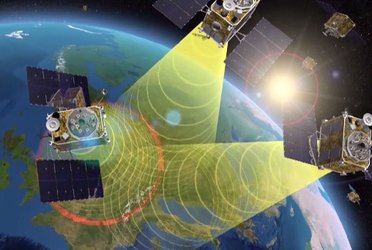
The purpose of the European Geostationary Navigation Overlay Service, EGNOS, is to monitor the real-time performance of US GPS satellites, then generate a correction message, containing information on the reliability and accuracy of their positioning data, which are then broadcast via EGNOS’s geostationary satellites to all suitably equipped satnav receivers.

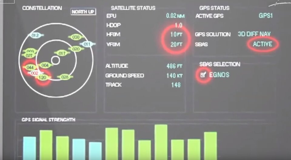
The end result is a several-fold increase in positioning accuracy and reliability – which is expressed for aviation users through the notion of its ‘integrity’ – how much can it relied upon at any given time. EGNOS typically allows users in Europe and beyond to determine their position to within 1.5 metres with a very high level of integrity, allowing aircraft to be safely guided down to airport runways.
EGNOS consists of three geostationary satellites and a Europe-wide ground segment composed of two master control stations, six uplink stations and a network of 40 monitoring stations, all connected and communicating in real time.

EGNOS was a joint project of ESA, the European Commission and Eurocontrol, the European Organisation for the Safety of Air Navigation. The system’s Open Service began on 1 October 2009, after which EGNOS positioning data became freely available in Europe through satellite signals to anyone equipped with an EGNOS-enabled GPS receiver.
The system is employed for accuracy and integrity-hungry satnav applications such as precision farming, surveying and transport. EGNOS is, for instance, used within the new eCall system, found in all new cars sold in the EU since March 2018. Whenever a serious accident occurs, eCall automatically passes the incident location to the emergency services, with EGNOS providing added accuracy and integrity.

But as the European equivalent of the US Wide Area Augmentation System WAAS, EGNOS was primarily designed to serve aviation, specifically for the safety-critical task of guiding down aircraft for landings. This became possible on 2 March 2011, when EGNOS’s ‘Safety-of-Life’ service began to operate.
Today more than 350 airports - more than half of the total – across Europe employ EGNOS. To do so, they have been certified for what are known as ‘LPV-200 procedures’ allowing pilots to take their aircraft down to 60 m (200 ft) above the ground for a final go/no-go decision on continued landing descent. LPV stands for ‘localiser performance with vertical guidance’.
This certification allows airports to operate without costly ground-based Instrument Landing System ‘Cat-1’ infrastructure. Major airports hubs such as Paris Charles de Gaulle, Frankfurt and Amsterdam Schiphol employ EGNOS for landing approaches. For smaller regional airports, EGNOS allows them to stay open in all weathers.
The EGNOS Exploitation Program is managed by the European Global Navigation Satellite System Agency, GSA. ESA retains the role of developing its future System evolution, taking shape as ‘EGNOS V3’ in the coming decade, which will augment signals from both GPS and Galileo satellites for added performance, reliability and extended coverage.


Access the video