About ESA
The European Space Agency (ESA) is Europe’s gateway to space. Its mission is to shape the development of Europe’s space capability and ensure that investment in space continues to deliver benefits to the citizens of Europe and the world.
Highlights


Latest


Space in Member States
Find out more about space activities in our 23 Member States, and understand how ESA works together with their national agencies, institutions and organisations.
 Germany
 Austria
 Belgium
 Denmark
 Spain
Spain
 Estonia
 Finland
 France
 Greece
 Hungary
 Ireland
 Italy
Italy
 Luxembourg
 Norway
 The Netherlands
 Poland
 Portugal
 Czechia
 Romania
 United Kingdom
 Slovenia
 Sweden
 Switzerland
Science & Exploration
Exploring our Solar System and unlocking the secrets of the Universe
Go to topicAstronauts


Latest


Enabling & Support
Making space accessible and developing the technologies for the future
Go to topicLatest


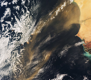
Sahara sand and dust seen by ESA's Envisat
Envisat captures sand and dust from the Sahara Desert blowing across the Atlantic Ocean along the coasts of Mauritania (top), Senegal (middle) and Guinea Bissau (bottom). The cloud-covered Cape Verde islands are visible off the coast of Senegal.
Sandstorms, or dust storms, are usually the result of atmospheric convection currents, which form when warm, lighter air rises and cold, heavier air sinks. Dust from the Sahara Desert can be transported over thousands of kilometres by convection currents, which also cause other meteorological conditions, such as thunderstorms.
Sandstorms are very common over the Sahara, which is a major source of mineral dust, and large concentrations of it can be found in the tropical Atlantic and the Caribbean.
Saharan dust plays an important role in the Mediterranean region because it is the major source of mineral nutrients for phytoplankton – the basic food on which all other marine life depends. It is not always beneficial, however. In the Caribbean, Saharan dust is believed to infect coral reefs with the sea fan disease.
The dust is also thought to be linked to health risks, such as increased incidences of paediatric asthma attacks in the Caribbean and epidemics of lethal meningitis in the semi-arid sub-Saharan territory known as the Sahel belt.
This image was acquired on 29 March 2008 by Envisat’s Medium Resolution Imaging Spectrometer (MERIS) instrument while working in Full Resolution mode to provide a spatial resolution of 300 metres.