About ESA
The European Space Agency (ESA) is Europe’s gateway to space. Its mission is to shape the development of Europe’s space capability and ensure that investment in space continues to deliver benefits to the citizens of Europe and the world.
Highlights


Latest


Space in Member States
Find out more about space activities in our 23 Member States, and understand how ESA works together with their national agencies, institutions and organisations.
 Germany
 Austria
 Belgium
 Denmark
 Spain
Spain
 Estonia
 Finland
 France
 Greece
 Hungary
 Ireland
 Italy
Italy
 Luxembourg
 Norway
 The Netherlands
 Poland
 Portugal
 Czechia
 Romania
 United Kingdom
 Slovenia
 Sweden
 Switzerland
Science & Exploration
Exploring our Solar System and unlocking the secrets of the Universe
Go to topicAstronauts


Latest


Enabling & Support
Making space accessible and developing the technologies for the future
Go to topicLatest


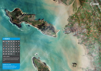
French synergy
Capital of the Charente-Maritime department in western France, La Rochelle and surroundings are featured in this Sentinel-2A image, captured on 26 December 2015.
Home to some 80 000 people, La Rochelle is a city and a seaport on the Bay of Biscay, a part of the Atlantic Ocean, connected to the Île de Ré by a 2.9 km-long bridge, clearly visible in the centre of the image.
La Rochelle and surrounding areas sit on layers of limestone dating back some 160 million years, when a large part of France was under water. These various layers containing many small marine fossils are traditionally used as the main construction material throughout the region.
The coastal area is dominated by sandy beaches, which are visible as white lines somewhat inland. Between the beach and the water-line, darker sand and silt layers are visible, which are exposed in this image taken during low tide.
The 4–5 m tidal range creates a heaven for wild mussels and oysters, making it one of the major places for shell farming in Europe.
Also visible just north of the city is the La Rochelle-Ile de Ré airport.
Thanks to the high-resolution multispectral instrument on Sentinel-2A, we can clearly make out the various agricultural fields around the city and surrounding towns, as well as on the Île de Ré Island.
Part of the Natural Reserve of the Bay of Aiguillon is visible at top right. It is one of the most important reserves in France, hosting hundreds of thousands of migratory water birds every year.
It is a place of synergy between land and sea, between saltwater and freshwater, and between nature and humankind.
Sentinel-2A has been in orbit since 23 June 2015 as a polar-orbiting, high-resolution satellite for land monitoring, providing imagery of vegetation, soil and water cover, inland waterways and coastal areas.
This image is also featured on the Earth from Space video programme.