About ESA
The European Space Agency (ESA) is Europe’s gateway to space. Its mission is to shape the development of Europe’s space capability and ensure that investment in space continues to deliver benefits to the citizens of Europe and the world.
Highlights


Latest


Space in Member States
Find out more about space activities in our 23 Member States, and understand how ESA works together with their national agencies, institutions and organisations.
 Germany
 Austria
 Belgium
 Denmark
 Spain
Spain
 Estonia
 Finland
 France
 Greece
 Hungary
 Ireland
 Italy
Italy
 Luxembourg
 Norway
 The Netherlands
 Poland
 Portugal
 Czechia
 Romania
 United Kingdom
 Slovenia
 Sweden
 Switzerland
Science & Exploration
Exploring our Solar System and unlocking the secrets of the Universe
Go to topicAstronauts


Latest


Enabling & Support
Making space accessible and developing the technologies for the future
Go to topicLatest


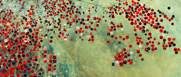
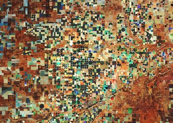
Yuma chequerboard
This false-colour Sentinel-2A image captured on 20 August 2015 takes us to the city of Yuma in the United States, in southwestern Arizona.
Visible in the image in scattered greys, Yuma is home to some 90 000 people. Situated along the Colorado River, the Mexican frontier lies just west of it and California lies to the north.
The fence forming the border is visible as a fine and perfectly straight line, running from left to right through the image between the irrigation canal and the irrigated fields west of the city. Just north of the canal, a small square marks a water reservoir for irrigating the fields in this highly arid region.
Founded in 1854, Yuma is the centre of large irrigation districts that converted parts of the desert into rich farmland.
It is considered to be the winter vegetable capital of the US because it has some of the most fertile soil in the country, stemming from sediments deposited by the Colorado River over thousands of years. These lay the foundation for making it the third most productive in the entire US for vegetables. It is also known for wheat – two thirds is exported, mainly to Italy for producing premium pasta.
The false-colour bands render the farmed fields in varying shades of browns and red. The circular features are created by centre-pivot irrigation, while rectangular fields use different irrigation methods that deliver the water along straight lines. The shades of red indicate how sensitive the multispectral instrument on Sentinel-2A is to differences in chlorophyll content, providing key information on vegetation health.
Also visible in the image are the Yuma International Airport just south of town, and parts of the Kofa National Wildlife Refuge to the east, which protects the desert bighorn sheep, while offering hiking and camping in the rugged wilderness.
Sentinel-2A has been in orbit since 23 June 2015 as a polar-orbiting, high-resolution satellite for land monitoring, providing imagery of vegetation, soil and water cover, inland waterways and coastal areas.
This image is also featured on the Earth from Space video programme.