About ESA
The European Space Agency (ESA) is Europe’s gateway to space. Its mission is to shape the development of Europe’s space capability and ensure that investment in space continues to deliver benefits to the citizens of Europe and the world.
Highlights


Latest


Space in Member States
Find out more about space activities in our 23 Member States, and understand how ESA works together with their national agencies, institutions and organisations.
 Germany
 Austria
 Belgium
 Denmark
 Spain
Spain
 Estonia
 Finland
 France
 Greece
 Hungary
 Ireland
 Italy
Italy
 Luxembourg
 Norway
 The Netherlands
 Poland
 Portugal
 Czechia
 Romania
 United Kingdom
 Slovenia
 Sweden
 Switzerland
Science & Exploration
Exploring our Solar System and unlocking the secrets of the Universe
Go to topicAstronauts


Latest


Enabling & Support
Making space accessible and developing the technologies for the future
Go to topicLatest


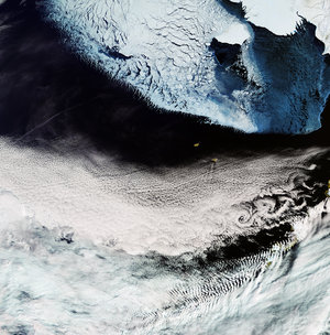
Bering in dire straits
The Bering Strait is a sea passage that separates Russia and Alaska. It is usually covered with sea ice at this time of year – but as this image captured by the Copernicus Sentinel-1 mission on 7 March 2019 shows, it is virtually ice-free.
The Bering Strait is a narrow passage - around 80 km wide - connecting the Pacific and Arctic Oceans. The few patches of sea ice are shown in light-blue colours.
The extent of sea ice in the Bering Sea has dropped lower than it has been since written records began in 1850, and is most likely because of warm air and water temperatures. On average, the fluctuating sea ice in this region increases until early April, depending on wind and wave movement.
According to the National Snow & Ice Data Center, between 27 January to 3 March 2019, sea-ice extent decreased from 566 000 sq km to 193 000 sq km. Sea ice was also exceptionally low last year, but it has been reported that this March the extent of sea ice is the lowest in the 40-year satellite record.
To travel between Arctic and Pacific, marine traffic passes through the Bering Strait. Owing to the reduction of ice in the region, traffic has increased significantly.
The Copernicus Sentinel-1 satellites provide images to generate maps of sea-ice conditions for safe passage in the busy Arctic waters, as well as distinguish between thinner, more navigable first-year ice and thicker, more hazardous ice. Each satellite carries an advanced radar instrument to image Earth’s surface through cloud and rain, regardless of whether it is day or night.