About ESA
The European Space Agency (ESA) is Europe’s gateway to space. Its mission is to shape the development of Europe’s space capability and ensure that investment in space continues to deliver benefits to the citizens of Europe and the world.
Highlights


Latest


Space in Member States
Find out more about space activities in our 23 Member States, and understand how ESA works together with their national agencies, institutions and organisations.
 Germany
 Austria
 Belgium
 Denmark
 Spain
Spain
 Estonia
 Finland
 France
 Greece
 Hungary
 Ireland
 Italy
Italy
 Luxembourg
 Norway
 The Netherlands
 Poland
 Portugal
 Czechia
 Romania
 United Kingdom
 Slovenia
 Sweden
 Switzerland
Science & Exploration
Exploring our Solar System and unlocking the secrets of the Universe
Go to topicAstronauts


Latest


Enabling & Support
Making space accessible and developing the technologies for the future
Go to topicLatest


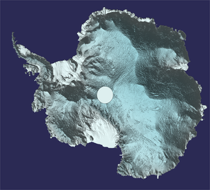
Antarctica detailed in 3D
Unfortunately ice is a hot topic when it comes to understanding and monitoring how this fragile component of the Earth system is being affected by climate change. Scientists, therefore, go to great lengths to study changes happening in the remote icy reaches of our planet – a subject that is being discussed in detail at this week’s Living Planet Symposium in Italy. Among the results being presented is a novel 3D dataset of Antarctica. Scientists from the University of Edinburgh, UK, created this new view by processing data from ESA’s CryoSat in a clever way.
CryoSat carries a radar altimeter that measures the height of the world’s ice. Typically, the data are used to map the height of ice at single points. And, since it was launched in 2010, this has revealed much about how ice sheets, glaciers and sea ice are changing.
Nevertheless, a technique called ‘swath processing’ takes the data to a new level. Scientists have used CryoSat’s novel ‘interferometric mode’ to produce whole swaths of data and in much finer detail and faster than is gained by conventional radar altimetry. The usual spatial resolution of a few kilometres has been improved to less than one kilometre.
The technique is allowing scientists to better understand change and predict how ice sheets, glaciers and ice caps may behave as climate change takes a stronger grip. This is important with respect to global concerns such as sea-level rise.
The team used this method to map Greenland in 2017, and now the Antarctica model is available. Both datasets can be downloaded from the CryoTop website.