About ESA
The European Space Agency (ESA) is Europe’s gateway to space. Its mission is to shape the development of Europe’s space capability and ensure that investment in space continues to deliver benefits to the citizens of Europe and the world.
Highlights


Latest


Space in Member States
Find out more about space activities in our 23 Member States, and understand how ESA works together with their national agencies, institutions and organisations.
 Germany
 Austria
 Belgium
 Denmark
 Spain
Spain
 Estonia
 Finland
 France
 Greece
 Hungary
 Ireland
 Italy
Italy
 Luxembourg
 Norway
 The Netherlands
 Poland
 Portugal
 Czechia
 Romania
 United Kingdom
 Slovenia
 Sweden
 Switzerland
Science & Exploration
Exploring our Solar System and unlocking the secrets of the Universe
Go to topicAstronauts


Latest


Enabling & Support
Making space accessible and developing the technologies for the future
Go to topicLatest


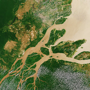
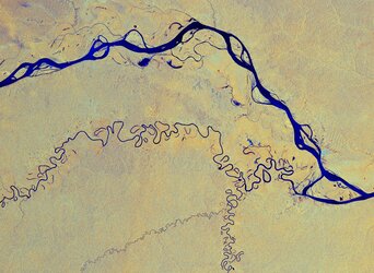
‘Meeting of waters’
The Copernicus Sentinel-2 mission takes us over the ‘meeting of waters’ in Brazil – where the Rio Negro and the Solimões River meet to form the Amazon River.
Click on the box in the lower-right corner to view this image at its full 10 m resolution directly in your browser.
The Rio Negro, visible in black, is the largest tributary of the Amazon and the world’s largest black-water river. It flows 2300 km from Colombia, and it gets its dark colouring from leaf and plant matter that has decayed and dissolved in its waters.
The Rio Negro contrasts significantly with the Solimões River – visible directly below - which owes its brown-colouring to its rich sediment content, including sand, mud and silt. After flowing for around 1600 km, the Solimões River meets the Rio Negro and together form this important junction.
Owing to differences in temperature, speed and water density, the two rivers, after converging, flow side-by-side for a few kilometres , before eventually mixing.
Manaus, the largest city in the Amazon Basin, is visible on the north bank of the Rio Negro. Despite being 1500 km from the ocean, Manaus is a major inland port. The Adolfo Ducke Forest Reserve is visible northeast of the city. The almost square-shaped block of land is a protected area named after the botanist Adolfo Ducke, and is used for the research of biodiversity.
Copernicus Sentinel-2 is a two-satellite mission. Each satellite carries a high-resolution camera that images Earth’s surface in 13 spectral bands and can help monitor changes in land cover and inland waters.
This image, captured on 7 February 2018, is also featured on the Earth from Space video programme.