About ESA
The European Space Agency (ESA) is Europe’s gateway to space. Its mission is to shape the development of Europe’s space capability and ensure that investment in space continues to deliver benefits to the citizens of Europe and the world.
Highlights


Latest


Space in Member States
Find out more about space activities in our 23 Member States, and understand how ESA works together with their national agencies, institutions and organisations.
 Germany
 Austria
 Belgium
 Denmark
 Spain
Spain
 Estonia
 Finland
 France
 Greece
 Hungary
 Ireland
 Italy
Italy
 Luxembourg
 Norway
 The Netherlands
 Poland
 Portugal
 Czechia
 Romania
 United Kingdom
 Slovenia
 Sweden
 Switzerland
Science & Exploration
Exploring our Solar System and unlocking the secrets of the Universe
Go to topicAstronauts


Latest


Enabling & Support
Making space accessible and developing the technologies for the future
Go to topicLatest


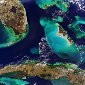
Andros, Bahamas
Andros Island, the largest island of the Bahamas, is featured in this false-colour image captured by the Copernicus Sentinel-2 mission. This image was processed in a way that included the near-infrared channel, which highlights the island’s vegetation in bright red.
Andros is around 160 km from north to south, and 70 km from east to west at its widest point. The island is largely unpopulated and has undeveloped stretches of land. Even though it is considered a single island, Andros is an archipelago made up of hundreds of small islets and cays connected by estuaries and swamplands together with three major islands: North Andros, Mangrove Cay and South Andros.
The island’s west coast features many bays, channels and inlets. The turquoise colours of the ocean show shallow waters, whereas the dark blue colours are the deep ocean.
The West Side National Park covers the west part of Andros and includesits pristine coastal wetlands. The 6000 sq km park is the largest protected area in the region,and is a prime habitat for bonefish and an important feeding area for the endangered West Indian flamingo.
This image was acquired on 5 September 2019, just days after the mighty Hurricane Dorian passed over the Bahamas and unleashed a siege of destruction. Dorian is reported to be one of the most powerful Atlantic hurricanes on record – with storm surges, wind and rain that claimed many lives, destroyed homes and left thousands of people homeless.
Compared to acquisitions captured in the days leading up to Hurricane Dorian making landfall, the area in the top-left of the image appears to be more flooded owing to heavy rainfall, and several submerged islands can be seen.
In response to Hurricane Dorian, the Copernicus Emergency Mapping Service was activated. The service uses observations from several Earth observation satellites, such as Copernicus Sentinel-1 and-2, to provide flood, risk and recovery maps.
This image is also featured on the Earth from Space video programme.