


 Germany
 Austria
 Belgium
 Denmark
 Spain
Spain
 Estonia
 Finland
 France
 Greece
 Hungary
 Ireland
 Italy
Italy
 Luxembourg
 Norway
 The Netherlands
 Poland
 Portugal
 Czechia
 Romania
 United Kingdom
 Slovenia
 Sweden
 Switzerland


Types of orbits
In brief
Our understanding of orbits, first established by Johannes Kepler in the 17th century, remains foundational even after 400 years. Today, Europe continues this legacy with a family of rockets launched from Europe’s Spaceport into a wide range of orbits around Earth, the Moon, the Sun and other planetary bodies.
In-depth

What is an orbit?
An orbit is the curved path that an object in space (like a star, planet, moon, asteroid or spacecraft) follows around another object due to gravity.
Gravity pulls objects with mass towards each other. If this attraction brings them together with enough momentum, they can start to orbit each other.
Objects of similar mass orbit each other with neither object at the centre, while small objects orbit around larger objects. In our Solar System, the Moon orbits Earth and the Earth-Moon system orbits the Sun, but that does not mean the larger object remains completely still. Because of gravity, Earth is pulled slightly from its centre by the Moon (which is why tides form in our oceans), and our Sun is pulled slightly from its centre by Earth and the other planets.
The early formation of our Solar System about 4.6 billion years ago began with an enormous swirling cloud of dust and gas, held together by gravity. Its core became so dense and massive that it collapsed under its own gravity, igniting to become our Sun. Around this early star, the remaining material from the interstellar cloud continued to spin around the Sun with great momentum, gradually flattening due to centrifugal forces into a disc called the solar nebula. The huge Sun at the cloud’s core kept these bits of gas, dust and ice in orbit around it, shaping it into a kind of ring around the Sun.
Eventually, these particles started to settle and clump together (or ‘coalesce’), growing ever larger like rolling snowballs until they formed what we now see as planets, comets and asteroids, and moons – although not our own. That the planets all formed together from this cloud of rotating dust explains why they all orbit the Sun in the same direction, in roughly the same plane.

When rockets launch our satellites, they put them into orbit in space. There, gravity keeps the satellite in its required orbit – in the same way that gravity keeps the Moon in orbit around Earth.
This happens in a way that is similar to throwing a ball out of the window of a tall tower – to get the ball going, you need to first give it a ‘push’ by throwing it, making the ball fall towards the ground on a curved path. Whilst it is your throw that gives the ball its initial speed, it is gravity alone that keeps the ball moving towards the ground once you let go.
Similarly, a satellite is put into orbit by being placed a few hundred or even thousands of kilometres above Earth’s surface, where it is no longer in danger of being decelerated by the denser parts of Earth’s atmosphere. From here, as if at the top of a very tall tower, it is then given a ‘push’ by the rocket’s engines to make it begin its orbit.
As shown in the figure, throwing something off the ‘tower’ will make it fall on a curved path toward the ground – but a really powerful throw will impart so much speed to the object that the ground starts to curve away before your object reaches it. Your object will fall ‘towards’ Earth indefinitely, causing it to circle the planet repeatedly. Congratulations! You have reached orbit.
In space, there is no air and therefore no air friction, so gravity lets a satellite orbit around Earth with almost no further assistance. Putting satellites into orbit enables us to use technologies for telecommunication, navigation, weather forecasting, emergency response and astronomy observations.

Launch to orbit
The role of a launcher is, therefore, first to pass through the atmosphere with its cargo, and then to provide the horizontal velocity push necessary to get into orbit.
Europe’s rockets operate from Europe’s Spaceport in French Guiana, and each mission delivers one or more satellites – payloads – into carefully designated orbits.
The choice of which launch vehicle to use depends primarily on the mass of the payload, but also on how far from Earth it needs to go. A heavy payload or a high-altitude or interplanetary orbit requires more power to fight Earth’s gravity than a lighter payload and a lower altitude.
Ariane 6 is Europe’s most powerful rocket, capable of lifting one, two, or multiple satellites into their required orbits. Depending on which orbit Ariane 6 is going to, it can launch approximately 21.5 tonnes into space – that is 21 500 kg, about the mass of a grey whale.
Vega-C is smaller than Ariane 6, capable of launching roughly 2.2 tonnes at a time, making it an ideal launch vehicle for many scientific and Earth observation missions. Both Ariane 6 and Vega-C can deploy multiple satellites at a time.
Ariane 6 and Vega-C are Europe’s new generation of rockets, following on from Ariane 5 and Vega. They are more flexible, have greater payload capacity and will expand Europe’s launch capacity, able also to deliver payloads to several different orbits in a single flight – like a bus making multiple stops.
Types of orbit
Upon launch, a satellite or spacecraft is usually placed in one of several specific orbits around Earth, or it may be sent on an interplanetary journey, meaning it no longer orbits Earth, but instead orbits the Sun, perhaps until it arrives at another final destination, like Mars, Jupiter, or even a comet.
Many factors influence the choice of an optimal orbit for a space mission, all depending on the mission’s objectives.

Geostationary orbit (GEO)
Satellites in geostationary orbit (GEO) fly above Earth’s equator, moving from west to east, exactly matching Earth’s rotation: taking 23 hours 56 minutes and 4 seconds to complete one full orbit, i.e. the duration of a sidereal day. This makes GEO satellites appear ‘stationary’ over one fixed spot. To keep pace with Earth’s spin, they travel at about 3 km per second at an altitude of 35 786 km, much farther than most satellites.
GEO is ideal for satellites that need to stay fixed above a specific location, such as telecommunication satellites, allowing antennas on Earth to stay in a constant position, always pointing at the satellite. It is also valuable for weather satellites, enabling continuous monitoring specific regions to track evolving weather patterns over times and see how weather trends emerge.
Satellites in GEO can cover a large portion of Earth; just three evenly spaced satellites can provide near-global coverage. Being far away allows these satellites a view of larger areas, similar to how you see more of a map standing a metre away from it compared to with your nose up close to it. To see all of Earth at once from GEO, far fewer satellites are needed than at lower altitudes.
ESA’s European Data Relay System (EDRS) programme consists of a constellation of GEO satellites that relay information and data between non-GEO satellites, spacecraft and ground stations that are otherwise unable to permanently transmit or receive data. This means Europe can always stay connected and online, even with satellites in lower orbits that have reduced visibility from the ground.

Low Earth orbit (LEO)
A low Earth orbit (LEO) is, as the name suggests, an orbit that is relatively close to Earth’s surface. LEO is considered to be under altitudes of 2000 km, this upper limit a consequence of the Van Allen belts above and the harsh environment they create. The lower limit for how low a satellite can fly is down to the impact of Earth’s atmosphere. Generally, satellites do not fly below 180 km for this reason – low compared to most orbits, but still very far above Earth’s surface.
By comparison, most commercial aeroplanes do not fly higher than approximately 12 km, so even the lowest LEO is more than ten times higher.
Unlike satellites in GEO that orbit along Earth’s equator, LEO satellites can have their orbital planes tilted at various angles.
LEO’s close proximity to Earth is useful for several reasons. It is ideal for satellite imaging, as its closeness allows for higher resolution images. The International Space Station (ISS) also orbits here as the shorter distance makes it easier for astronauts to reach. Satellites in low-Earth orbit travel at approximately 7.8 km per second with respect to Earth, completing an orbit in about 90 minutes. This means the ISS circles Earth roughly 16 times a day.
As such, communications satellites in LEO often work as part of a constellation, a networking of several of the same or similar satellites working together to provide continuous coverage in a ‘net’ around Earth. The same can apply to observation or navigation constellations.
Ariane 5 carried its heaviest 20-tonne payload, the Automated Transfer Vehicle (ATV), five times to the ISS. In the future, Ariane 6 may take over this task and launch supplies to space stations in Earth or lunar orbit.

Polar orbit (PO)
Polar orbits are a type of low Earth orbit, typically between 200 to 1000 km in altitude. Satellites in polar orbits usually travel around Earth from, roughly, one pole to the other, rather than from west to east. They do not need to pass exactly over the North and South Poles; a deviation of 10 degrees is still classed as a polar orbit.
Polar orbits are particularly useful for global Earth coverage, as satellites orbiting ‘up’ and ‘down’ Earth’s surface can see every inch of the planet over time as it also rotates below.
Sun synchronous orbit (SSO)
Sun-synchronous orbit (SSO) is a particular kind of polar orbit in which satellites are in sync with the Sun. Matching Earth’s rotation around the Sun, they always appear in the same position relative to our star. This means they pass over the same spot on Earth at the same local time every day – for example passing over the city of Paris daily at noon.
This consistency allows for the accurate monitoring of changes over days, weeks, months or even years, as images are more comparable in terms of light and shadows. Scientists use SSO and this ability to compare like-for-like images over time to investigate how weather patterns emerge, help predict extreme weather events, monitor emergencies like forest fires or flooding and to accumulate data on long-term problems like deforestation or rising sea levels.
Often, satellites in SSO are synchronised so that they are in constant dawn or dusk, constantly riding a sunset or sunrise and ensuring as consistent as possible illumination/shadows. A satellite in a Sun-synchronous orbit usually flies at an altitude of between 600 to 800 km. At 800 km, it will travel at a speed of approximately 7.5 km per second.
Medium Earth orbit (MEO)
Medium Earth orbit (MEO) covers a wide range of altitudes anywhere between LEO – usually over the top of the Van Allen belts – and GEO. Like LEO, satellites in MEO do not need to follow specific paths around Earth and the orbit is used by a variety of satellites for many different purposes.
MEO is very commonly used by navigation satellites, like the European Galileo system (pictured). Galileo provides navigation services across the world, helping with everything from tracking large jumbo jets to giving directions on your smartphone. Galileo consists of a constellation of satellites that provide simultaneous coverage over large areas of the world.

Transfer orbits and Geostationary Transfer Orbit (GTO)
Transfer orbits are a special kind of orbit used to get from one orbit to another. When satellites are launched from Earth by rockets like Ariane 6, they are not always placed directly into their final orbit. Instead, they are often put into an initial transfer orbit where, using energy from onboard motors, the satellite or spacecraft can move from one orbit to another.
For example, to reach a high-altitude orbit like GEO, a satellite doesn’t need the launch vehicle to take it all the way. Instead, the satellite is placed in a special type of transfer orbit called a geostationary transfer orbit (GTO), which serves as a shortcut.
Orbits have different shapes or ‘eccentricities’ – a measure of how circular (round) or elliptical (squashed) they are. In a perfectly round orbit, a satellite is always the same distance from Earth’s surface, but in a highly eccentric orbit, the satellite moves closer and farther from Earth as it travels.
In transfer orbits, satellites or spacecraft use their engines to go from an orbit of one eccentricity to another, which puts it on track for an orbit at higher or lower altitudes, but also to modify their orbital inclination and semi-major axis.
After liftoff, a launch vehicle makes its way to space following a path like that shown in yellow (pictured). The rocket releases its payload at a target point, releasing it into an elliptical orbit, (in blue), taking the payload far from Earth before it would then get close again. The point farthest from Earth in an elliptical orbit is the apogee, and the point closest is the perigee.
To get to GEO, when a satellite reaches its apogee of 35 786 km, (the GEO altitude) it fires its engines in such a way that it circularises its orbit, entering into a circular geostationary orbit and staying there, shown by the red line in the diagram.
When a satellite is launched from a non-equatorial site, e.g. from Kourou, 500km north of the equator, the transfer orbit is inclined. The manoeuvre at apogee is also used to cancel out this inclination and bring the satellite to the equator.
When the launch site is far from the equator, e.g. from Cape Canaveral, fuel can be saved when the apogee is higher, sometimes much higher, than the GEO altitude. In this case, we refer to a ‘Supersynchronous’ transfer orbit, which is much more eccentric than GTO.
Highly eccentric orbit (HEO)
Orbits, like people, can be highly eccentric. As a spacecraft flies on a highly eccentric orbit, its distance from Earth, the Sun, or whichever body it is locked around varies greatly, coming close at vast speeds and then whizzing away far into space and slowing down before returning again.
The eccentricity of orbits is denoted by numbers from zero to one, with perfectly circular orbits rating zero while a highly eccentric orbit is closer to (but always less than) one. A score of one would mean an orbit is ‘parabolic', i.e. the shape of a parabola – think of a symmetrical ‘U’ shaped curve – reaching just enough energy to escape the gravitational pull of the central object, never to return. Above one and an orbit is 'hyperbolic’, with more than enough speed to escape the Earth (or other central gravitational body).
Comets have highly eccentric orbits around the Sun as they formed at the far edges of the Solar System. Their orbital eccentricity can get very close to one (Halley’s Comet has an eccentricity of 0.967), and they can take many millions of years to complete a full orbit around the Sun. Made of ice and dust, they spend the majority of their lives in the cold of the outer Solar System, and sometimes don’t survive their fleeting close encounters with the Sun.
HEO is very useful for missions that need to observe Earth or look into space from high altitudes for extended periods. ESA’s upcoming SMILE mission, for example, will fly in HEO to study the interactions between the solar wind and Earth’s magnetosphere. The spacecraft's orbit will allow it to spend long periods far from Earth to observe large-scale processes.
HEO can also be used as a transfer orbit for an interplanetary mission, or to reach GEO when the launch site is far from the equator, e.g. Cape Canaveral or Baikonur.
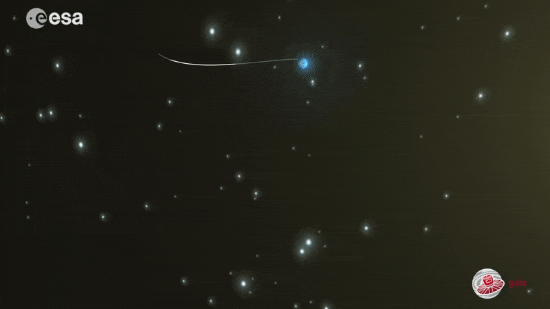
Lagrange points
There are regions in space where the gravitational influence of two large masses, like the Sun and Earth, or Earth and Moon, ‘balance out’, causing a whole range of orbits to appear – the so-called Lagrange, or libration points.
Some spacecraft need to avoid being too close to Earth, because Earth’s light, radiation and shadow can interfere with their mission – even at more distant orbits such as GEO. This makes Lagrange points particularly useful for missions that rely on incredible precision and stability, such as deep space astronomical missions like Gaia and Euclid.
For space-based observatories and telescopes whose mission is to photograph deep, dark space, being next to Earth is hugely detrimental because as Earth naturally emits infrared radiation (thermal emission) and reflects visible sunlight that prevents the telescope detecting faint light from, for example, distant galaxies. Photographing dark space with a telescope next to our glowing Earth would be as hopeless as trying to take pictures of stars from Earth in broad daylight.
Lagrange points, or L-points, allow for orbits that are much, much farther away (approximately 1.5 million kilometres) and do not orbit Earth directly. These are specific points in space where the gravitational fields of Earth and the Sun combine in such a way that spacecraft can orbit the points themselves, remaining stable with little effort and thus ‘anchored’ relative to Earth.
If a spacecraft was launched to other random points in space far from Earth, they would naturally fall into an orbit around the Sun or Earth, taking them far from Earth and making communication extremely difficult. Instead, spacecraft launched to these special L-points remain roughly fixed in a frame rotating with the Earth, close-enough to Earth and with minimal effort without going into a different orbit.
The most commonly used Lagrange points are L1 and L2, located about 1.5 million kilometres from Earth – roughly four times the distance to the Moon and about 1% of the distance from Earth to the Sun. When a spacecraft reaches L1 or L2, it typically follows is an oval-shaped path around the fictitious libration point called a Halo orbit, or, a smaller, ‘Lissajous’ orbit that looks like a spirograph drawing.
Several of ESA’s observational and science missions were, are, or will enter into orbit about the Lagrange points. The SOHO solar telescope is now orbiting the first Sun-Earth Lagrangian point, where LISA Pathfinder also flew. Herschel, Planck, Gaia, Euclid, Plato, Ariel, JWST and the Athena telescope have been or will be orbiting the Sun-Earth point L2.
Heliocentric orbit
Some missions don’t orbit Earth, but instead join it and the other planets of the Solar System in orbiting the Sun in heliocentric orbit. This kind of orbit is useful of course for missions studying our star, but also for those studying other planets, moons, comets and asteroids or deep space, as it allows spacecraft to travel vast distances without being tied to Earth's gravity or position in the Solar System.
To enter into a heliocentric orbit, a spacecraft must first escape Earth’s gravity by reaching a speed called ‘escape velocity’ – in other words they follow a hyperbolic trajectory. Once this speed is achieved, the spacecraft can move beyond Earth's influence and become captured instead by the Sun’s gravity. This transition is typically done using powerful launch vehicles, followed by trajectory adjustments using the spacecraft’s own engines.
ESA’s Solar Orbiter mission is in a heliocentric orbit to study the Sun up close. From a distance of 42 million km, more than three times closer than the Earth, and at an inclination 33 degrees above the solar equator, Solar Orbiter even has a view of the Sun’s little-seen poles.
Rosetta also followed a heliocentric path to rendezvous with and study the comet 67P/Churyumov-Gerasimenko, and other future ESA missions, like Comet Interceptor, will also make use of heliocentric orbits to explore distant comets and other celestial bodies in our Solar System.
When flying around the Sun, and far from any planets, a spacecraft follows an orbit as if it were orbiting Earth – almost always an ellipses with varying eccentricities. From here, its path can then planned so that it encounters planets and perform gravity assist manoeuvres, which allow us to modify the spacecraft's trajectory for ‘free’.
When a spacecraft has enough initial velocity, it leaves Earth to orbit the Sun. To also escape the Sun and so the Solar System, only two missions to date have had enough velocity: Voyager 1 and 2.