Complex data made easy
While the growing volume information from satellites observing Earth offers a unique opportunity for science and applications, it is sometimes difficult to make sure these complex data streams are exploited to their full potential. ESA is addressing this challenge with ‘Thematic Exploitation Platforms’.
The idea is to unlock satellite data and make the information available to the non-expert along with the tools and resources they need – and critically make all this accessible from one place.
This frees up time and resources for the user so they can focus on creating innovative information products and services using Earth observation data.
There are six Thematic Exploitation Platforms – or TEPs for short. They cover geohazards, coastal environments, forestry, hydrology, polar regions and urban environments.

Participants at this week’s Living Planet Symposium in the Czech Republic have been learning how this initiative has been making life easier for users since the project was launched less than two years ago.
One focus was on the Geohazards Exploitation Platform (GEP), which gives users direct access to a powerful processing capacity to exploit large Earth-observation datasets. It is designed to support the users looking at geohazards such as seismic risks, volcanoes, subsidence and landslides.
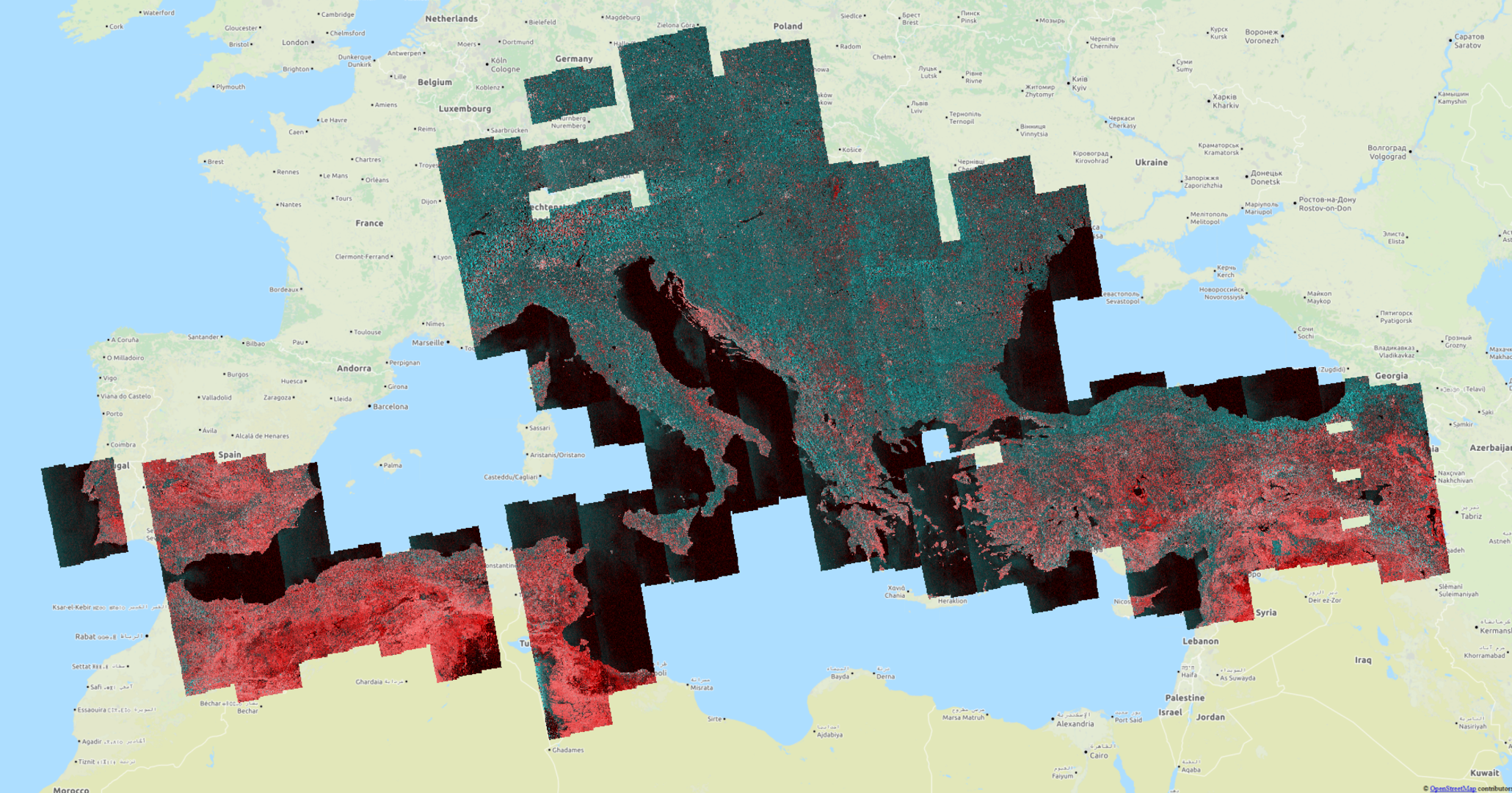
ESA has recently agreed with the DLR German Aerospace Center and Terradue to provide ‘interferometric synthetic aperture radar’ images through their browse service.
While the GEP is funded by ESA, the activity is led by Terradue, a company specialised in Cloud platform operations and information and communications technologies for processing huge amounts of geospatial information.

The images are intended for visualisation purposes and not as products designed for use in further processing chains. This new service is, however, a concrete example of new capabilities provided by the Cloud-based GEP. Importantly, it helps users to assess whether they need further full-resolution measurements through one of the on-demand GEP processors.
Pairs of Sentinel-1A radar images from consecutive passes of the same spot on Earth’s service are processed continuously and automatically to provide 200 m-resolution images.
These browse images are not downloadable but the ‘interferograms’ allow users to identify ground movement and other changes that may have occurred between satellite acquisitions.
The service currently covers the Europe’s tectonic area. Covering three million square km, this represents 360 interferometric pairs every 12 days.

Stefano Salvi from INGV said, “This development is a crucial step towards empowering society at large with the latest technology to reduce risk from geohazards.”
Once the Sentinel-1B satellite has been commissioned following being launched on 25 April, the service will double its production to 60 pairs every day.
In addition, 50 m-resolution products are also delivered to a pre-defined group of expert users working in ESA research and development studies looking mainly into volcanism.
Over the coming months, the service will be gradually ramped up to cover the global tectonic ‘mask’. This mask corresponds to regions where the shape of the ground is deforming because of tectonic activity and prioritised by the geohazards user community. In fact, the area amounts to 20% of Earth’s land surface.


 Germany
 Austria
 Belgium
 Denmark
 Spain
Spain
 Estonia
 Finland
 France
 Greece
 Hungary
 Ireland
 Italy
Italy
 Luxembourg
 Norway
 The Netherlands
 Poland
 Portugal
 Czechia
 Romania
 United Kingdom
 Slovenia
 Sweden
 Switzerland


