Earth observation highlighted at UN biological diversity conference
Addressing the global issue of biodiversity loss, participants from all over the world recently gathered in Germany to attend the UN's Convention of Biological Diversity Conference of Parties. During the conference, data from Earth observation satellites was highlighted as playing a crucial role in the conservation of biological diversity and sustainable development.
In recognition of the importance of biological diversity in sustaining the Earth's population of six billion, the UN Convention on Biological Diversity (UNCBD) was signed by 150 government leaders at the Earth Summit in Rio de Janeiro, Brazil in 1992. As a result, world governments have agreed to significantly reduce the current rate of biodiversity loss by 2010. The Conference of Parties (COP) is the Convention's governing body and advances implementation of the Convention through the decisions it takes at periodic meetings.

The ninth meeting of the COP was held in Bonn, Germany from 19-30 May and was attended by almost 7000 participants from 191 countries. ESA hosted a side event at COP9, in which speakers from various UN agencies highlighted the overarching role that Earth observation (EO) satellites play in providing vital information to implement and assess the progress of several UN treaties related to biodiversity. The side event was chaired by Gerald Braun who is from the German Space Agency (DLR) and an ESA delegate.
Representatives from the Ramsar Convention on Wetlands, the UN Convention to Combat Desertification (UNCCD) and the UNESCO World Heritage Convention, which are all supported by ESA, expressed their satisfaction and confirmed the usefulness of EO data. Nick Davidson from the Ramsar Convention on Wetlands introduced the GlobWetland project as an example of how EO data can be used for wetland assessment, monitoring and management.
He said that, "Often made up of complex and inaccessible terrain, monitoring ecological changes in wetlands without the use of satellite data is very difficult. The project produces land-use cover and change detection maps for use by wetland managers and policymakers. ESA EO data has considerable power and potential in providing the intelligence behind making sound decisions on management and policy."

Also speaking at the event, UNESCO's Mario Hernandez outlined joint programmes undertaken by UNESCO and ESA, including mapping World Heritage sites such as in ESA's Diversity project and gorilla natural-habitat monitoring. The Diversity project, which kicked-off last year, aims to contribute to the monitoring efforts that will help the UNCBD determine whether progress is being made in reducing biodiversity loss and provide insight into which policy measures are proving most effective. For example, the Diversity project has demonstrated the use of EO data for monitoring selected headline indicators of biodiversity loss such as trends in the extent of global drylands.
Lúcio de Rosário from the Portuguese National Focal Point Assistant for the UN Convention to Combat Desertification (UNCCD also spoke at the event and presented DesertWatch, a joint UNCCD-ESA programme designed to assist parties with implementation.

The importance of land-cover mapping was very evident at the meeting and was included as being an important tool by many of the speakers. In particular, Martin Herold from Global Observation for Forest and Land Cover Dynamics expressed the potential for satellite observations for the post-2012 negotiations of the UN Framework Convention on Climate Change and for driving national observation progress for forests.
From an economic perspective, Jean-Louis Weber from the European Environment Agency (EEA) provided insight into a less obvious way in which EO data is helping measure how the loss of biodiversity is affecting our quality of life in terms of wealth. The current thinking is that when calculating a country's gross domestic product, a monetary value should be included to represent the costs to an ecosystem that have come about through providing various goods and services.
An extensive study on ecosystem accounts for Mediterranean wetlands is being carried out that relies on land-cover maps derived from EO data to assess economic costs to the environment. This study is part of The Economics of Ecosystems and Biodiversity report - a joint German Ministry for Environment and European Commission initiative.

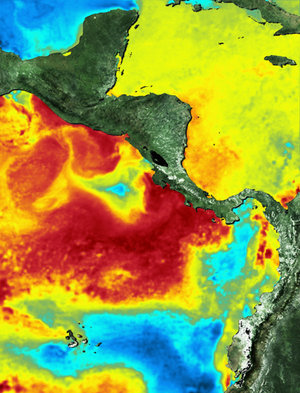
ESA's Oliver Arino also spoke during the event outlining support for a number of multilateral environment agreements, including those governing biodiversity, desertification, climate change, wetland and marine projects. For instance, he explained how sea-surface temperature maps matched with hammerhead shark tagging experiments show how migration routes are linked to ocean conditions.
The wildlife migration service developed within the Diversity project relies on near real-time satellite-derived maps of oceanographic conditions such as sea-surface temperature, water quality and surface currents in the Tropical East Pacific Corridor. The different EO data products are derived using results from ESA's Medispiration and GlobColour projects.
The essence, discussions held at the UNCBD-COP9 highlighted how EO-derived data is proving invaluable in providing an insight into the change of land cover as well as changes in marine and fresh water environments. Since biological diversity is intrinsically linked to such changes, biodiversity loss can be assessed at local, regional and global scales through a broad-range of applications. As the world's population grows and biodiversity diminishes, it was also made clear that EO-data is becoming an increasingly important tool in attempts to achieve sustainable development.


 Germany
 Austria
 Belgium
 Denmark
 Spain
Spain
 Estonia
 Finland
 France
 Greece
 Hungary
 Ireland
 Italy
Italy
 Luxembourg
 Norway
 The Netherlands
 Poland
 Portugal
 Czechia
 Romania
 United Kingdom
 Slovenia
 Sweden
 Switzerland


