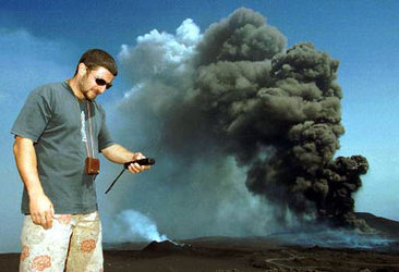
Three ESA satellites reveal Etna’s complexity
As detected by ESA satellite sensors, the recent eruptions of the Mount Etna volcano in Sicily are throwing huge amounts of ash and trace gases into the atmosphere. Instruments on three different ESA spacecraft have acquired imagery of the eruptions that shed new light on the event and its impact on the Earth’s environment.
Working with data from the Global Ozone Monitoring Experiment (GOME) sensor onboard ESA’s ERS-2 spacecraft, scientists at the German aerospace centre (DLR) report that levels of sulphur dioxide from the eruptions on Sunday and Monday are at least 20 times higher than normal.
This latest activity from Etna, the second in a little over a year, marks the beginning of another period of activity of Europe’s largest volcano, says Werner Thomas, an atmospheric scientist with DLR’s Remote Sensing Technology Institute.
“As in July and August 2001 eruptions of Etna, dense ash clouds and gaseous emissions were again detected by several space-borne sensors,” he said.

The normal background level of sulphur dioxide is typically below 0.5 Dobson Units (DU), a measure of atmospheric gas concentrations from ground level to the top of the atmosphere, about 70 km in altitude.
"In the plume, we measured atmospheric content of sulphur dioxide of about 10 DU, at least 20 times higher than normal," Thomas said.
Sulphur dioxide in the troposphere, the lowest part of the atmosphere where most weather changes occur, is known to be responsible for the so-called "acid rain" phenomenon. Stratospheric sulphur dioxide, from about 11 km to 50 km above the Earth’s surface, causes the formation of sulphate aerosol particles that may have a serious impact on the global climate. Etna is one of the most prominent sources of natural sulphur dioxide worldwide.

The ERS’ GOME instrument is dedicated for remote sensing of the atmosphere and can detect a variety of atmospheric trace gases, including sulphur dioxide. The first GOME data after the beginning of the eruptions was recorded and analysed on 29 October around 10:15 UTC. As seen in the accompanying chart, enhanced levels of sulphur dioxide are evident in the southeast of Sicily, indicating that the tropospheric sulphur dioxide was carried away from the volcano by the winds in that direction.
The Italian government declared a state of emergency yesterday in Sicily in the wake a series of earthquakes, measuring between 3.6 and 4.3 on the Richter scale, that forced the evacuation of approximately 1000 homes, according to reports from BBC and Italian newspapers. Meanwhile, three streams of lava from the eruption flowed down the south, northeast and northwest slopes of the mountains, the media reports stated.
Ash to affect global environment

Europe's highest and most active volcano (3370 m) hurled lava and ash from several craters into the sky with a speed between 350 and 450 metres per second, exceeding the speed of sound. According to data from volcanologists, the lava and ash were ejected from the main crater and from at least nine new craters that developed in the mountain between 2300 to 2700 metres in altitude.
As seen in the image acquired Monday by the Medium Resolution Imaging Spectrometer (MERIS) onboard ESA’s Envisat satellite, the eruptions spewed significant amounts of ash, along with sulphur dioxide, into the atmosphere The plume from the volcano can be seen in the image stretching south and west from Sicily to the north African coast. The larger volcanic ash particles are expected to settle out in a short period of time, but the sulphuric acid aerosols produced by the sulphur dioxide will persist for several years.
These aerosols will impact the Earth’s energy budget, both regionally and on a global scale. Aerosols containing black graphite and carbon particles are dark, thus absorbing sunlight. As these atmospheric particles reduce the amount of sunlight reaching the planet’s surface, they increase the amount of solar energy absorbed in the atmosphere, thus simultaneously cooling the surface and warming the atmosphere.
The capability of the MERIS instrument to observe the spatial distribution of these aerosol plumes can be exploited to measure the amounts of airborne particles and to examine the role of these aerosols as cloud condensation nuclei and their impact on the hydrologic cycle through changes in cloud cover, cloud properties and precipitation.
Today’s images from Proba

Just 60x60x80 cm and weighing only 94 kg, ESA’s Project for On-Board Autonomy satellite, better known as Proba, is one of the most advanced small satellites ever flown in space.

Since its launch last year, Proba’s high-performing computer system and technologically advanced instruments have enabled it to demonstrate and evaluate onboard operational autonomy, new spacecraft technology both hardware and software, and to test Earth observation and space environment instruments in space.
The imagery captured today by Proba demonstrate the capabilities of CHRIS, the Compact High Resolution Imaging Spectrometer, which is providing important information on the Earth and its environment, and will be a valuable tool in remote sensing during the extended mission.
The instrument acquired the accompanying Etna images in four standard bands, although the instrument is capable of image acquisition in up to 19 different bands.


 Germany
 Austria
 Belgium
 Denmark
 Spain
Spain
 Estonia
 Finland
 France
 Greece
 Hungary
 Ireland
 Italy
Italy
 Luxembourg
 Norway
 The Netherlands
 Poland
 Portugal
 Czechia
 Romania
 United Kingdom
 Slovenia
 Sweden
 Switzerland


