About ESA
The European Space Agency (ESA) is Europe’s gateway to space. Its mission is to shape the development of Europe’s space capability and ensure that investment in space continues to deliver benefits to the citizens of Europe and the world.
Highlights


Latest


Space in Member States
Find out more about space activities in our 23 Member States, and understand how ESA works together with their national agencies, institutions and organisations.
 Germany
 Austria
 Belgium
 Denmark
 Spain
Spain
 Estonia
 Finland
 France
 Greece
 Hungary
 Ireland
 Italy
Italy
 Luxembourg
 Norway
 The Netherlands
 Poland
 Portugal
 Czechia
 Romania
 United Kingdom
 Slovenia
 Sweden
 Switzerland
Science & Exploration
Exploring our Solar System and unlocking the secrets of the Universe
Go to topicAstronauts


Latest


Enabling & Support
Making space accessible and developing the technologies for the future
Go to topicLatest


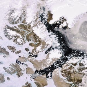
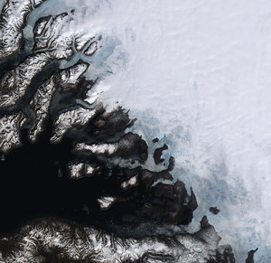
Arctic islands
This Envisat radar image features the eastern side of Ellesmere Island (left), the northernmost Canadian island, and portions of the northwest coast of Greenland (right), the world’s largest island.
Ellesmere Island, the world’s tenth largest island, is considered part of the Queen Elizabeth Islands, the northernmost cluster of islands in the Canadian Arctic Archipelago. Glaciers and ice caps cover some 80 000 sq km of Ellesmere Island.
Inglefield Land is visible in the bottom right corner with the gray colour contrasting against the white and aqua blue colours of an ice cap.
In the image, blue, purple and green colours represent the waters of Nares Strait, which comprises several bodies of water. The narrow passage between Inglefield Land and Ellesmere Island is the Smith Sound, which extends some 88 km from Baffin Bay to the south (not visible) to the Kane Basin (dark blue water located above Inglefield Land). Kane Basin is where Greenland’s Humboldt Glacier, the largest known glacier in the world, discharges.
As radar images represent surface backscatter rather than reflected light, there is no colour in a standard radar image. This image was created by combining three Envisat Advanced Synthetic Aperture Radar acquisitions (2 February 2009, 14 April 2009 and 10 November 2009) taken over the same area. The colours in the image result from variations in the surface that occurred between acquisitions.