About ESA
The European Space Agency (ESA) is Europe’s gateway to space. Its mission is to shape the development of Europe’s space capability and ensure that investment in space continues to deliver benefits to the citizens of Europe and the world.
Highlights


Latest


Space in Member States
Find out more about space activities in our 23 Member States, and understand how ESA works together with their national agencies, institutions and organisations.
 Germany
 Austria
 Belgium
 Denmark
 Spain
Spain
 Estonia
 Finland
 France
 Greece
 Hungary
 Ireland
 Italy
Italy
 Luxembourg
 Norway
 The Netherlands
 Poland
 Portugal
 Czechia
 Romania
 United Kingdom
 Slovenia
 Sweden
 Switzerland
Science & Exploration
Exploring our Solar System and unlocking the secrets of the Universe
Go to topicAstronauts


Latest


Enabling & Support
Making space accessible and developing the technologies for the future
Go to topicLatest


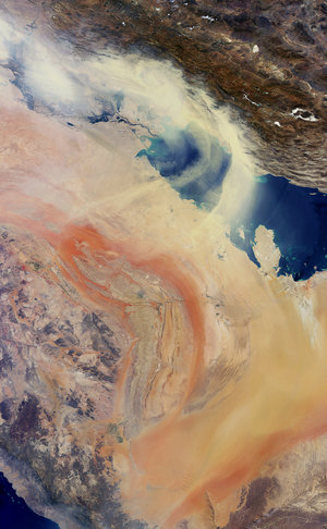
Persian coast
This image acquired over the Middle East shows the northern end of the Persian Gulf, along with the border of Iran and Iraq and the mouth of the Shatt al-Arab river.
The main part of the image covers Iran’s southern Khuzestan Province on the Persian Gulf.
The lines cutting through the middle of the image are roads, as well as the Trans-Iranian Railway.
In the upper-left corner, we can see part of the Karun River. It is the country’s only navigable river, originating in the Zagros mountains and running its 720 km course southwest and into the Shatt al-Arab river.
In addition to the Karun, the Shatt al-Arab also carries water from the Tigris and Euphrates to the Persian Gulf.
In the lower-left corner, we can see the Shatt al-Arab where it creates part of the border with Iraq. The marshy Faw Peninsula (part of which is visible to the extreme left) is the site of a number of important Iraqi oil installations.
The Persian Gulf and its coastal areas are the world’s largest single source of crude oil, with related industries dominating the region.
The centre of the image is dominated by the marshes and mudflats of the Shadegan wildlife refuge. It is the largest wetland in Iran, and plays a significant role in the natural ecology of the area.
The area provides a wintering habitat for a wide variety of migratory birds, and is the most important site in the world for a rare species of aquatic bird – the marbled duck.
The northern part of the wetland is a vital freshwater habitat for many endangered species.
This image was acquired on 26 July 2012 by the Enhanced Thematic Mapper on Landsat 7. Landsat 7 imagery accounts for the largest parts of Earth’s surface displayed on web mapping services such as Google Earth and Google Maps.