About ESA
The European Space Agency (ESA) is Europe’s gateway to space. Its mission is to shape the development of Europe’s space capability and ensure that investment in space continues to deliver benefits to the citizens of Europe and the world.
Highlights


Latest


Space in Member States
Find out more about space activities in our 23 Member States, and understand how ESA works together with their national agencies, institutions and organisations.
 Germany
 Austria
 Belgium
 Denmark
 Spain
Spain
 Estonia
 Finland
 France
 Greece
 Hungary
 Ireland
 Italy
Italy
 Luxembourg
 Norway
 The Netherlands
 Poland
 Portugal
 Czechia
 Romania
 United Kingdom
 Slovenia
 Sweden
 Switzerland
Science & Exploration
Exploring our Solar System and unlocking the secrets of the Universe
Go to topicAstronauts


Latest


Enabling & Support
Making space accessible and developing the technologies for the future
Go to topicLatest


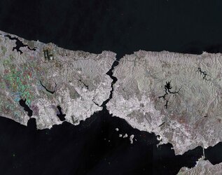
Istanbul, Turkey
Istanbul and the surrounding area in northwestern Turkey are captured in this image acquired by Envisat’s MERIS instrument on 9 June 2011. To the north is the Black Sea, which connects to the Sea of Marmara (centre) via the Bosphorus strait. The Dardanelles strait connects the Marmara to the Aegean Sea (lower left corner). Turkey's largest city, Istanbul, is near the centre of the image at the Bosphorus strait. Istanbul straddles two continents (Europe and Asia), making it a true meeting place of the East and the West.
Turkey’s location makes it vulnerable to earthquakes, with the 1000 km-long North Anatolian fault just 15 km south of Istanbul. Because earthquakes can suddenly render current maps out of date, satellite images are useful for updating views of how the landscape has been affected as well as creating reference cartography for emergency operations. In addition, before and after satellite images of the area enable authoritative damage assessment as a basis for planning remedial action.