About ESA
The European Space Agency (ESA) is Europe’s gateway to space. Its mission is to shape the development of Europe’s space capability and ensure that investment in space continues to deliver benefits to the citizens of Europe and the world.
Highlights


Latest


Space in Member States
Find out more about space activities in our 23 Member States, and understand how ESA works together with their national agencies, institutions and organisations.
 Germany
 Austria
 Belgium
 Denmark
 Spain
Spain
 Estonia
 Finland
 France
 Greece
 Hungary
 Ireland
 Italy
Italy
 Luxembourg
 Norway
 The Netherlands
 Poland
 Portugal
 Czechia
 Romania
 United Kingdom
 Slovenia
 Sweden
 Switzerland
Science & Exploration
Exploring our Solar System and unlocking the secrets of the Universe
Go to topicAstronauts


Latest


Enabling & Support
Making space accessible and developing the technologies for the future
Go to topicLatest


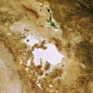
Radar image of the Salar de Uyuni, Bolivia
This radar image is one of the first from the Sentinel-1A satellite, acquired on 20 April – less than three weeks after its launch on 3 April.
The image shows the Salar de Uyuni in Bolivia, which is the largest salt flat in the world.
Occupying over 10 000 sq km, the vast Salar de Uyuni lies at the southern end of the Altiplano, a high plain of inland drainage in the central Andes. Some 40 000 years ago, this area was part of a giant prehistoric lake that dried out, leaving behind the salt flat.
While the salt flat appears an almost homogenous white in optical satellite imagery, here we see it in shades of grey, and it looks almost like a lake. This has to do with how the radar signal reacts to different surfaces: areas where the radar signal is absorbed appear darker, while areas where the signal is reflected back to the satellite appear lighter. This gives Earth observation experts an indication of how rough or smooth the surfaces area, differences in salt density or even the presence of water.
But on the whole, the Salar de Uyuni is very flat, with a surface elevation variation of less than 1 m. This makes the area ideal for calibrating satellite radar altimeters – a different kind of radar instrument that measures surface topography. The future Sentinel-3 mission will carry a radar altimeter.
The surrounding terrain is rough in comparison to the vast salt flat and is dominated by the volcanoes of the Andes mountains forming part of the Pacific Ring of Fire.
Sentinel-1A is the first in the two-satellite Sentinel-1 mission for Europe’s Copernicus programme. Its radar data will be used for a variety of applications, including the surveillance of the marine environment, monitoring land-surface for motion risks, mapping for forest, water and soil management, and mapping to support humanitarian aid and crisis situations.
This image is featured on the Earth from Space video programme.