About ESA
The European Space Agency (ESA) is Europe’s gateway to space. Its mission is to shape the development of Europe’s space capability and ensure that investment in space continues to deliver benefits to the citizens of Europe and the world.
Highlights


Latest


Space in Member States
Find out more about space activities in our 23 Member States, and understand how ESA works together with their national agencies, institutions and organisations.
 Germany
 Austria
 Belgium
 Denmark
 Spain
Spain
 Estonia
 Finland
 France
 Greece
 Hungary
 Ireland
 Italy
Italy
 Luxembourg
 Norway
 The Netherlands
 Poland
 Portugal
 Czechia
 Romania
 United Kingdom
 Slovenia
 Sweden
 Switzerland
Science & Exploration
Exploring our Solar System and unlocking the secrets of the Universe
Go to topicAstronauts


Latest


Enabling & Support
Making space accessible and developing the technologies for the future
Go to topicLatest


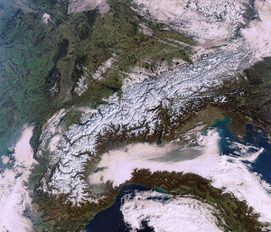
Aletsch Glacier
Parts of the Swiss and Italian Alps are pictured in this satellite image.
Extending some 1200 km through central Europe, the Alps occupy an area of about 200 000 sq km and are inhabited by some 20 million people.
Near the centre of the image we can see the Aletsch Glacier, the largest in the Alps. The glacier originates in a large, flat area of snow and ice high in the mountains called Concordia, where three smaller glaciers converge. It extends south, and its meltwater creates the Massa River in the valley below.
Owing to climate change, the glaciers in this region are showing long-term retreat. The melting ice has given birth to new lakes, which pose risks such as flooding and landslides to communities below.
Aletsch and the surrounding mountains are part of the Jungfrau-Aletsch protected area, a UNESCO World Heritage site. The area is of major importance to scientific research in geology, geomorphology, climatic change, biology and atmospheric physics. It features a wide diversity of ecosystems, and its landscape has played an important role in European art, literature, mountaineering and alpine tourism.
One particularly popular tourist destination is the city of Interlaken, located between lakes Thun and Brienz, seen in the upper part of the image. From the city, locals and visitors alike have easy access to the mountains and water bodies, and can partake in a variety of outdoor activities during all seasons.
This image, also featured on the Earth from Space video programme, was acquired by the Landsat-8 satellite on 8 June 2014 and laid over a digital elevation model to give us this 3D perspective.