About ESA
The European Space Agency (ESA) is Europe’s gateway to space. Its mission is to shape the development of Europe’s space capability and ensure that investment in space continues to deliver benefits to the citizens of Europe and the world.
Highlights


Latest


Space in Member States
Find out more about space activities in our 23 Member States, and understand how ESA works together with their national agencies, institutions and organisations.
 Germany
 Austria
 Belgium
 Denmark
 Spain
Spain
 Estonia
 Finland
 France
 Greece
 Hungary
 Ireland
 Italy
Italy
 Luxembourg
 Norway
 The Netherlands
 Poland
 Portugal
 Czechia
 Romania
 United Kingdom
 Slovenia
 Sweden
 Switzerland
Science & Exploration
Exploring our Solar System and unlocking the secrets of the Universe
Go to topicAstronauts


Latest


Enabling & Support
Making space accessible and developing the technologies for the future
Go to topicLatest


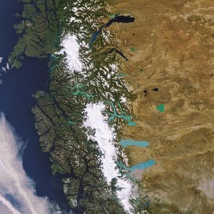
Los Glaciares National Park, Argentina
Part of the Southern Patagonian Ice Field – the world's second largest contiguous extrapolar ice field – and two lakes are pictured in this image of Argentina’s Los Glaciares National Park.
The park was named a UNESCO World Heritage site in 1981, is situated in the area around Lake Viedma (top of image) and the country’s largest freshwater Lake Argentino (below). Both are fed by water from melting glaciers and by rivers and their unique colour is attributed to ‘glacier milk’: suspended fine sediment produced by the abrasion of glaciers rubbing against rock.
The majority of the nearly 50 big glaciers fed by the Patagonian Ice Field in the park have been retreating during the last 50 years because of warming temperatures. In the upper left we can see the Viedma Glacier feeding Lake Viedma. To its south is the Upsala Glacier, which has retreated more than 3 km in the past 15 years.
At the centre-bottom of the image is the Perito Moreno glacier, the most famous glacier in the park because of its rupture process, and one of the few not retreating or advancing but appearing to be in equilibrium, going through cycles of retreats and advances.
Located on a narrow channel that separates the main body of Lake Argentino from its southern arm, Perito Moreno forms an ice dam when it advances to the extent that it reaches the land on the other side of the channel, creating two separate bodies of water.
Once the dam is formed, water and ice commence a kind of duel: water from melting glaciers drain into the trapped section of lake, and the force of the rising waters inevitably becomes too much and the ice dam gives way to crushing lake waters trapped behind it, finally breaking apart. This process first occurred in 1917, submerging a several-hundred-year-old forest, and has occurred over twenty times since then.
This image, also featured on the Earth from Space video programme, was acquired by the Landsat-8 satellite on 28 February 2014.