About ESA
The European Space Agency (ESA) is Europe’s gateway to space. Its mission is to shape the development of Europe’s space capability and ensure that investment in space continues to deliver benefits to the citizens of Europe and the world.
Highlights


Latest


Space in Member States
Find out more about space activities in our 23 Member States, and understand how ESA works together with their national agencies, institutions and organisations.
 Germany
 Austria
 Belgium
 Denmark
 Spain
Spain
 Estonia
 Finland
 France
 Greece
 Hungary
 Ireland
 Italy
Italy
 Luxembourg
 Norway
 The Netherlands
 Poland
 Portugal
 Czechia
 Romania
 United Kingdom
 Slovenia
 Sweden
 Switzerland
Science & Exploration
Exploring our Solar System and unlocking the secrets of the Universe
Go to topicAstronauts


Latest


Enabling & Support
Making space accessible and developing the technologies for the future
Go to topicLatest


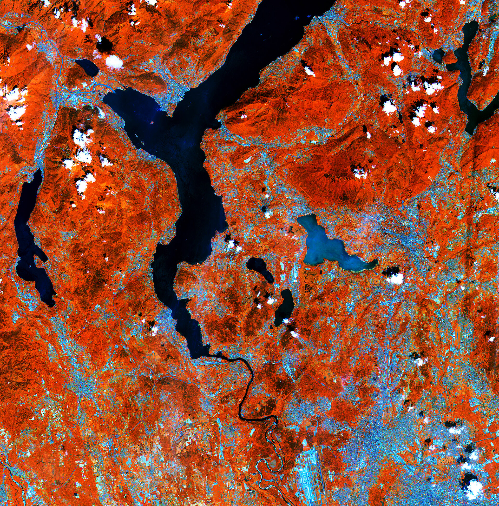
Northern Italy
Lakes on the southern side of the Italian Alps are pictured in this early acquisition by the Sentinel-2A satellite.
Processed using the high-resolution infrared channel of the satellite’s multispectral camera, the image shows healthy vegetation in red, such as the hills and mountains in the upper part of the image.
From the top of the image we see the southern part of Lake Maggiore. Straddling the border of Italy’s Lombardy and Piedmont regions – with its northern end in Switzerland (not visible) – the lake covers an area of over 210 sq km.
Its outlet, the Ticino river, snakes south past Milan–Malpensa Airport at the bottom of the image.
Near the centre of the image is the glacial Lake Varese, appearing lighter blue compared to the other lakes in the image. This demonstrates Sentinel-2’s ability to measure differences in the conditions of inland water bodies – one of the mission’s main applications along with land cover, agriculture and forestry.
This image, also featured on the Earth from Space video programme, is a subset of Sentinel-2’s very first acquisition on 27 June 2015, just four days after launch.
The satellite is in its commissioning phase, which includes calibrating its multispectral imager. But the initial images from its first scan of Earth foreshadow the mission’s land-monitoring applications in areas such as agriculture, the monitoring of inland and coastal waters and land-cover mapping.