About ESA
The European Space Agency (ESA) is Europe’s gateway to space. Its mission is to shape the development of Europe’s space capability and ensure that investment in space continues to deliver benefits to the citizens of Europe and the world.
Highlights


Latest


Space in Member States
Find out more about space activities in our 23 Member States, and understand how ESA works together with their national agencies, institutions and organisations.
 Germany
 Austria
 Belgium
 Denmark
 Spain
Spain
 Estonia
 Finland
 France
 Greece
 Hungary
 Ireland
 Italy
Italy
 Luxembourg
 Norway
 The Netherlands
 Poland
 Portugal
 Czechia
 Romania
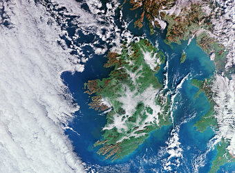
 United Kingdom
 Slovenia
 Sweden
 Switzerland
Science & Exploration
Exploring our Solar System and unlocking the secrets of the Universe
Go to topicAstronauts


Latest


Enabling & Support
Making space accessible and developing the technologies for the future
Go to topicLatest


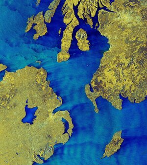
Irish mosaic
The Sentinel-1A satellite takes us over to Ireland, in this multi-temporal colour composite of land coverage across the island.
With a coastline of 7500 km, Ireland is home to some 4.8 million people and a wealth of history and tradition.
Stretching 486 km from north to south and 275 km across, Ireland is washed by abundant rainfall all year, coating the country in omnipresent emerald-green grasslands.
The coastal mountain fringes in the west, northwest and east are composed mainly of granite, while old red sandstone predominates in the south. Many lakes, large bog areas and low ridges make up the very scenic lowland, as seen throughout the image.
This image was stitched together from 16 radar scans by the satellite during May 2015, and gives us an idea of the island’s land cover and use.
Different colours show changes that occurred within the 12 days’ coverage.
The blues across the entire image represent strong changes in bodies of water or agricultural activities such as ploughing.
The yellows represent urban centres, with the capital city of Dublin very distinct on the far middle right. An interesting feature is the many yellow ‘spots’ scattered throughout the entire island, visible even more clearly when zooming in. These clusters all represent farmhouses.
Vegetated fields and forests appear in green. The reds and oranges represent unchanging features such as bare soil or possibly rocks that border the forests, as is clear on the left side of the image, along the tips of the island.
Sentinel-1A has been in orbit since 3 April 2014. It is a polar-orbiting, all-weather, day-and-night radar imaging mission for land and ocean services, monitoring the marine environment and mapping water and soil surfaces, among other major applications. Its sister, Sentinel-1B, is scheduled for launch on 22 April.
This image is also featured on the Earth from Space video programme.