About ESA
The European Space Agency (ESA) is Europe’s gateway to space. Its mission is to shape the development of Europe’s space capability and ensure that investment in space continues to deliver benefits to the citizens of Europe and the world.
Highlights


Latest


Space in Member States
Find out more about space activities in our 23 Member States, and understand how ESA works together with their national agencies, institutions and organisations.
 Germany
 Austria
 Belgium
 Denmark
 Spain
Spain
 Estonia
 Finland
 France
 Greece
 Hungary
 Ireland
 Italy
Italy
 Luxembourg
 Norway
 The Netherlands
 Poland
 Portugal
 Czechia
 Romania
 United Kingdom
 Slovenia
 Sweden
 Switzerland
Science & Exploration
Exploring our Solar System and unlocking the secrets of the Universe
Go to topicAstronauts


Latest


Enabling & Support
Making space accessible and developing the technologies for the future
Go to topicLatest


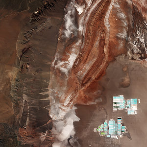
Chile's salt flat
The Sentinel-2A satellite takes us to the diverse landscape of the eastern Atacama desert in South America. The region pictured lies around 200km east of the Chilean city of Antofagasta on the Pacific coast (not pictured), and is virtually devoid of vegetation.
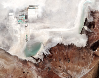
At the top of the image we can see part of Chile’s largest salt flat, the Salar de Atacama. With an average elevation of some 2300 m above sea level, it is formed by waters flowing down from the Andes, which, having no drainage outlets, are forced to evaporate, leaving salt deposits.
It is the world’s largest and purest active source of lithium, containing some 30% of the world's lithium reserve base, and providing almost 30% of the world’s lithium carbonate supply.
The bright turquoise rectangles and squares visible along the top part of the image are evaporation ponds. Subsurface salt brines are pumped from beneath the saline crust in two different areas. In one of them, extracted salt brines have unrivalled concentration levels of potassium and lithium. In the other, the brines obtained contain high concentrations of sulphate and boron.
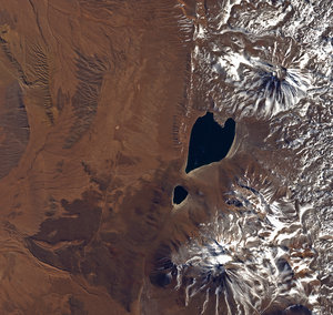
In the lower right part of the image we can see the Socompa stratovolcano, known for its ‘debris avalanche deposit’ where the land collapsed on its western rim some 7000 years ago. The area has since been partially filled by lava, and we can see dark lava flows around the volcano.
The multispectral instrument on Sentinel-2 uses parts of the infrared spectrum to analyse mineral composition where vegetation is sporadic. In this false-colour image, the intense shades of brown and orange come from the use of an infrared part of the spectrum leading to an exaggeration of colour intensity.
This image – also featured on the Earth from Space video programme – was captured by Sentinel-2A on 8 March. The satellite is the first in the twin satellite Sentinel-2 mission for Europe’s Copernicus programme, and carries a wide-swath high-resolution multispectral imager with 13 spectral bands, for a new angle on our land and vegetation.