Accept all cookies Accept only essential cookies See our Cookie Notice

About ESA
The European Space Agency (ESA) is Europe’s gateway to space. Its mission is to shape the development of Europe’s space capability and ensure that investment in space continues to deliver benefits to the citizens of Europe and the world.
Highlights
ESA - United space in Europe
This is ESA ESA facts Member States & Cooperating States Funding Director General Top management For Member State Delegations European vision European Space Policy ESA & EU Space Councils Responsibility & Sustainability Annual Report Calendar of meetings Corporate newsEstablishments & sites
ESA Headquarters ESA ESTEC ESA ESOC ESA ESRIN ESA EAC ESA ESAC Europe's Spaceport ESA ESEC ESA ECSAT Brussels Office Washington OfficeWorking with ESA
Business with ESA ESA Commercialisation Gateway Law at ESA Careers Cyber resilience at ESA IT at ESA Newsroom Partnerships Merchandising Licence Education Open Space Innovation Platform Integrity and Reporting Administrative Tribunal Health and SafetyMore about ESA
History ESA Historical Archives Exhibitions Publications Art & Culture ESA Merchandise Kids Diversity ESA Brand Centre ESA ChampionsLatest
Space in Member States
Find out more about space activities in our 23 Member States, and understand how ESA works together with their national agencies, institutions and organisations.
Science & Exploration
Exploring our Solar System and unlocking the secrets of the Universe
Go to topicAstronauts
Missions
Juice Euclid Webb Solar Orbiter BepiColombo Gaia ExoMars Cheops Exoplanet missions More missionsActivities
International Space Station Orion service module Gateway Concordia Caves & Pangaea BenefitsLatest
Space Safety
Protecting life and infrastructure on Earth and in orbit
Go to topicAsteroids
Asteroids and Planetary Defence Asteroid danger explained Flyeye telescope: asteroid detection Hera mission: asteroid deflection Near-Earth Object Coordination CentreSpace junk
About space debris Space debris by the numbers Space Environment Report In space refuelling, refurbishing and removingSafety from space
Clean Space ecodesign Zero Debris Technologies Space for Earth Supporting Sustainable DevelopmentLatest
Applications
Using space to benefit citizens and meet future challenges on Earth
Go to topicObserving the Earth
Observing the Earth Future EO Copernicus Meteorology Space for our climate Satellite missionsCommercialisation
ESA Commercialisation Gateway Open Space Innovation Platform Business Incubation ESA Space SolutionsLatest
Enabling & Support
Making space accessible and developing the technologies for the future
Go to topicBuilding missions
Space Engineering and Technology Test centre Laboratories Concurrent Design Facility Preparing for the future Shaping the Future Discovery and Preparation Advanced Concepts TeamSpace transportation
Space Transportation Ariane Vega Space Rider Future space transportation Boost! Europe's Spaceport Launches from Europe's Spaceport from 2012Latest
Switzerland
Thank you for liking
You have already liked this page, you can only like it once!
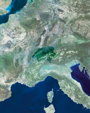
Multiple scans from the Copernicus Sentinel-2A satellite have been stitched together to create this complete image of Switzerland.
Click on the box in the lower-right corner to view this image at its full 10 m resolution directly in your browser.
The southern part of the country is dominated by the Alps, some of which are snow-capped. One of the more obvious features in the lower central part of the image is the curved x-shape of the Aletsch Glacier, the largest in the Alps. Owing to climate change, the glaciers in this region are showing long-term retreat.
North of the Alps, the landscape descends into the Central Plateau, which covers about a third of Switzerland and is home to major cities like Zurich and the de facto capital city, Bern. It is the most densely populated region and hosts the majority of the country’s industry, manufacturing and farming.
Along the northwestern edge of the country are the Jura mountains, consisting of a sequence of ‘folds’ in the geology, visible in the image as linear ridges running roughly southwest to northeast.
Switzerland has thousands of lakes shaped by glaciers during the last ice age, about 15 000 years ago. Lake Geneva in the west is shared with France, while Lake Constance in the east is shared with Germany and Austria, making Lake Neuchâtel in the northwest the largest entirely within Switzerland.
The lakes appear different colours owing to variations in algae content or to the presence of finely ground rock flowing in from the mountain glaciers.
Near the centre of the country we can see Lake Lucerne with its four ‘arms’. The city of Lucerne sits on the western end of the lake, and is the site of the latest ESA ministerial council.
Held on 1–2 December, ministers in charge of space activities from the 22 ESA Member States will meet to decide on Europe’s space activities.
ESA is proposing the next-generation scientific Earth observation programme at the council, focusing on the development of new satellites to address global challenges.
Other proposals address a smaller satellite for monitoring ozone in the stratosphere, the provision of essential data for climate research, and public–private partnerships.
This image is featured on the Earth from Space video programme.
-
CREDIT
contains modified Copernicus Sentinel data (2016), processed by GeoVille -
LICENCE
CC BY-SA 3.0 IGO or ESA Standard Licence
(content can be used under either licence)


 Germany
 Austria
 Belgium
 Denmark
 Spain
Spain
 Estonia
 Finland
 France
 Greece
 Hungary
 Ireland
 Italy
Italy
 Luxembourg
 Norway
 The Netherlands
 Poland
 Portugal
 Czechia
 Romania
 United Kingdom
 Slovenia
 Sweden
 Switzerland


