About ESA
The European Space Agency (ESA) is Europe’s gateway to space. Its mission is to shape the development of Europe’s space capability and ensure that investment in space continues to deliver benefits to the citizens of Europe and the world.
Highlights


Latest


Space in Member States
Find out more about space activities in our 23 Member States, and understand how ESA works together with their national agencies, institutions and organisations.
 Germany
 Austria
 Belgium
 Denmark
 Spain
Spain
 Estonia
 Finland
 France
 Greece
 Hungary
 Ireland
 Italy
Italy
 Luxembourg
 Norway
 The Netherlands
 Poland
 Portugal
 Czechia
 Romania
 United Kingdom
 Slovenia
 Sweden
 Switzerland
Science & Exploration
Exploring our Solar System and unlocking the secrets of the Universe
Go to topicAstronauts


Latest


Enabling & Support
Making space accessible and developing the technologies for the future
Go to topicLatest


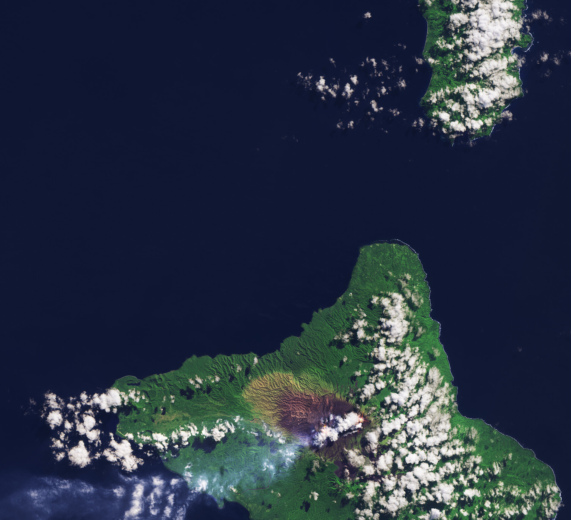
Ambrym, South Pacific Ocean
Sentinel-2A takes us to the Vanuatu archipelago in the South Pacific Ocean, roughly 1700 km east of Australia.
The islands we see are Pentecost to the north and Ambrym to the south.
Looking closely at the coastline, the white of breaking waves is more evident on the east coasts of the islands than on the west coasts. This is a common observation on islands that lie in the zone of the trade winds blowing mainly from south-easterly directions in the southern hemisphere.
Zooming in on the dark area on Ambrym, red-hot lava lakes can be seen through the clouds. This volcano has two active volcanic cones and we can see smoke drifting out over the ocean to the west.
The last time the Ambrym volcano erupted was in 1913, prompting the evacuation of nearby towns.
Ambrym’s 12 km-wide caldera was created around 50 AD by a large Plinian eruption – also called a ‘Vesuvian’ eruption because of the similarity with the explosion of Italy’s Mount Vesuvius that destroyed the towns of Pompeii and Herculaneum. These types of eruptions are marked by columns of gas and ash that extend high into the stratosphere. They also eject large amounts of pumice.
The volcano’s slopes appear black owing to the presence of basalt. As we move further away from the volcano the land becomes greener owing to the increased vegetation cover.
Sentinel-2 is able to systematically map different classes of cover such as forest, crops, grassland, water surfaces and artificial cover like roads and buildings. This information can be used to manage natural resources, to check rates of deforestation, reforestation and areas affected by wildfires. It can also help governing bodies and commercial enterprises make informed decisions about how best to manage, protect and sustain our important forest resources.
This image, also featured on the Earth from Space video programme, was captured by the Copernicus Sentinel-2A satellite on 24 June 2016.