About ESA
The European Space Agency (ESA) is Europe’s gateway to space. Its mission is to shape the development of Europe’s space capability and ensure that investment in space continues to deliver benefits to the citizens of Europe and the world.
Highlights


Latest


Space in Member States
Find out more about space activities in our 23 Member States, and understand how ESA works together with their national agencies, institutions and organisations.
 Germany
 Austria
 Belgium
 Denmark
 Spain
Spain
 Estonia
 Finland
 France
 Greece
 Hungary
 Ireland
 Italy
Italy
 Luxembourg
 Norway
 The Netherlands
 Poland
 Portugal
 Czechia
 Romania
 United Kingdom
 Slovenia
 Sweden
 Switzerland
Science & Exploration
Exploring our Solar System and unlocking the secrets of the Universe
Go to topicAstronauts


Latest


Enabling & Support
Making space accessible and developing the technologies for the future
Go to topicLatest


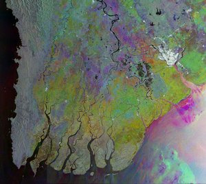
Irrawaddy Delta, Myanmar
The Sentinel-2A satellite takes us over the peninsulas and islands of the Irrawaddy Delta in Myanmar.
Click on the box in the lower-right corner to view this image at its full 10 m resolution directly in your browser.
With a length of over 2200 km, the Irrawaddy River is the country's largest, flowing north-to-south before fanning out into the delta and emptying into the Andaman Sea.
Evident by the brown colour of the rivers and streams, sediments carried by the water are deposited in the delta. These deposits make the area very fertile, and the accumulation of deposits over time causes the coastline to advance.
Owing to the rich soils, the region is the country’s largest rice producer. This image was captured in March after the harvesting season but before the planting, so bare ground appears beige.
Green areas show dense mangrove forests, especially the Mein-ma-hla Kyun Wildlife Sanctuary in the lower right, known for its saltwater crocodiles. Even though this area is protected, some villagers living on the banks nearby sneak into the sanctuary and chop down trees for wood, degrading the forest.
Wood collection, rice farming and fishing – these and other human activities have damaged the delta’s mangroves over the years. When Cyclone Nargis hit in 2008, the remaining mangrove forests were not enough to act as a natural buffer against the storm surge, and resulted in an extensive loss of life.
This image, also featured on the Earth from Space video programme, combines two acquisitions by the Copernicus Sentinel-2A satellite in March 2017.