About ESA
The European Space Agency (ESA) is Europe’s gateway to space. Its mission is to shape the development of Europe’s space capability and ensure that investment in space continues to deliver benefits to the citizens of Europe and the world.
Highlights


Latest


Space in Member States
Find out more about space activities in our 23 Member States, and understand how ESA works together with their national agencies, institutions and organisations.
 Germany
 Austria
 Belgium
 Denmark
 Spain
Spain
 Estonia
 Finland
 France
 Greece
 Hungary
 Ireland
 Italy
Italy
 Luxembourg
 Norway
 The Netherlands
 Poland
 Portugal
 Czechia
 Romania
 United Kingdom
 Slovenia
 Sweden
 Switzerland
Science & Exploration
Exploring our Solar System and unlocking the secrets of the Universe
Go to topicAstronauts


Latest


Enabling & Support
Making space accessible and developing the technologies for the future
Go to topicLatest


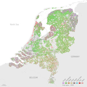
Mapping Germany’s agricultural landscape
Combining images captured by the Copernicus Sentinel-2 mission and the US Landsat-8 satellite between October 2015 and the end of 2016, this land-cover classification map shows different crops across Germany. A total of 2.2 TB of data were used to generate the map, which distinguishes between 21 land cover classes and includes 15 specific crop types.
Click on the box in the lower-right corner to view this image at its full 30 m resolution directly in your browser.
Clear pixels from all the satellite images were used to create a time series of 45 composites, each capturing the surface reflectance over a 10-day period, which can be related to crop type. Latest machine-learning software allowed this detailed map to be generated for the entire country.
While this early version of the map is still to be improved on, validation over the Brandenburg, Mecklenburg-Vorpommern and Bayern regions indicate an overall accuracy of 76%, with several crop types such as rapeseed, maize and sugar beet achieving accuracies of over 90%.
Having such detailed, spatially explicit, wall-to-wall results on land cover and crop types is a valuable source of information for a range of applications. Uses include supporting policies such as the EU Common Agricultural Policy, modelling biochemical fluxes and pollution, analysing land-use change, conserving biodiversity and managing natural resources.
Europe’s Copernicus Sentinel-2 mission provides important information for monitoring vegetation. Its multispectral camera has 13 spectral bands and is the first of its kind to include three bands in the ‘red edge’, which provide key data on vegetation state. The mission was designed to provide images that can be used to distinguish between different crop types as well as data on numerous plant indices, such as leaf area, leaf chlorophyll and leaf water – all essential to monitor plant growth accurately.