About ESA
The European Space Agency (ESA) is Europe’s gateway to space. Its mission is to shape the development of Europe’s space capability and ensure that investment in space continues to deliver benefits to the citizens of Europe and the world.
Highlights


Latest


Space in Member States
Find out more about space activities in our 23 Member States, and understand how ESA works together with their national agencies, institutions and organisations.
 Germany
 Austria
 Belgium
 Denmark
 Spain
Spain
 Estonia
 Finland
 France
 Greece
 Hungary
 Ireland
 Italy
Italy
 Luxembourg
 Norway
 The Netherlands
 Poland
 Portugal
 Czechia
 Romania
 United Kingdom
 Slovenia
 Sweden
 Switzerland
Science & Exploration
Exploring our Solar System and unlocking the secrets of the Universe
Go to topicAstronauts


Latest


Enabling & Support
Making space accessible and developing the technologies for the future
Go to topicLatest


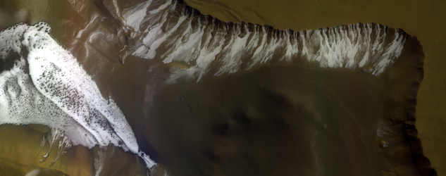
Clouds over lava flows on Mars
Diffuse, water-ice clouds, a hazy sky and a light breeze. Such might have read a weather forecast for the Tharsis volcanic region on Mars on 22 November 2016, when this image was taken by the ExoMars Trace Gas Orbiter.
Clouds, most likely of water-ice, and atmospheric haze in the sky are coloured blue/white in this image.
Below, 630 km west of the volcano Arsia Mons, the southernmost of the Tharsis volcanoes, outlines of ancient lava flows dominate the surface. The dark streaks are due to the action of wind on the dark-coloured basaltic sands, while redder patches are wind blown dust. A handful of small impact craters can also be seen.
The Trace Gas Orbiter, a joint effort between ESA and Roscosmos, arrived at Mars on 19 October last year. Since March it has been repeatedly surfing in and out of the atmosphere, generating a tiny amount of drag that will steadily pull it into a near-circular 400 km altitude orbit. It is expected to begin its full science operational phase from this orbit in early 2018.
Prior to this ‘aerobraking’ phase, several test periods were assigned to check the four science instrument suites from orbit and to refine data processing and calibration techniques.
The false-colour composite shown here was made from images taken with the Colour and Stereo Surface Imaging System, CaSSIS, in the near-infrared, red and blue channels.
The image is centred at 131°W / 8.5°S. The ground resolution is 20.35 m/pixel, and the image is about 58 km across. At the time the image was taken, the altitude was 1791 km, yielding a ground track speed of 1.953 km/s.