About ESA
The European Space Agency (ESA) is Europe’s gateway to space. Its mission is to shape the development of Europe’s space capability and ensure that investment in space continues to deliver benefits to the citizens of Europe and the world.
Highlights


Latest


Space in Member States
Find out more about space activities in our 23 Member States, and understand how ESA works together with their national agencies, institutions and organisations.
 Germany
 Austria
 Belgium
 Denmark
 Spain
Spain
 Estonia
 Finland
 France
 Greece
 Hungary
 Ireland
 Italy
Italy
 Luxembourg
 Norway
 The Netherlands
 Poland
 Portugal
 Czechia
 Romania
 United Kingdom
 Slovenia
 Sweden
 Switzerland
Science & Exploration
Exploring our Solar System and unlocking the secrets of the Universe
Go to topicAstronauts


Latest


Enabling & Support
Making space accessible and developing the technologies for the future
Go to topicLatest


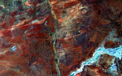
Western Australia
From the fourth most populous city to the rugged Outback, the Sentinel-3A satellite gives us a wide-ranging view over Australia’s southwestern corner.
This perspective from space clearly illustrates human’s influence on our environment: the agricultural landscape that dominates in the lower-left is suddenly interrupted by the more densely vegetated national parks and forests.
The city of Perth is located on the coast along the left edge of the image. About 150 km north of Perth sits ESA’s tracking station at New Norcia, where a 35 m-diameter radio dish communicates with deep-space missions such as Rosetta and Mars Express.
Moving further inland, grasslands give way to the deserts of Australia’s vast and remote interior – known as the Outback – with a landscape dominated by red soil and sparse vegetation. Several large salt lakes are visible across the image in white, including the appropriately named Lake Disappointment by explorer Frank Hann in search of fresh water (top of image).
Clouds over the ocean obstruct our view of the southern coast, but the lack of cloud cover over the interior desert pronounces the dry climate, which is a consequence of global wind patterns.
Sentinel-3 offers a ‘bigger picture’ for Europe’s Copernicus programme by systematically monitoring Earth’s oceans, land, ice and atmosphere to understand large-scale global dynamics.
While the satellite mission carries a suite of cutting-edge instruments, this image, also featured on the Earth from Space video programme, was captured on 9 April 2017 by the satellite’s Ocean and Land Colour Instrument, which helps to monitor ocean ecosystems, supports crop management and agriculture, and provides estimates of atmospheric aerosol and clouds.