About ESA
The European Space Agency (ESA) is Europe’s gateway to space. Its mission is to shape the development of Europe’s space capability and ensure that investment in space continues to deliver benefits to the citizens of Europe and the world.
Highlights


Latest


Space in Member States
Find out more about space activities in our 23 Member States, and understand how ESA works together with their national agencies, institutions and organisations.
 Germany
 Austria
 Belgium
 Denmark
 Spain
Spain
 Estonia
 Finland
 France
 Greece
 Hungary
 Ireland
 Italy
Italy
 Luxembourg
 Norway
 The Netherlands
 Poland
 Portugal
 Czechia
 Romania
 United Kingdom
 Slovenia
 Sweden
 Switzerland
Science & Exploration
Exploring our Solar System and unlocking the secrets of the Universe
Go to topicAstronauts


Latest


Enabling & Support
Making space accessible and developing the technologies for the future
Go to topicLatest


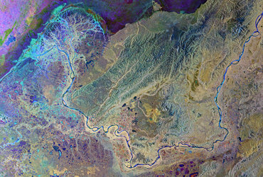
Yukon Delta
The Copernicus Sentinel-2 mission takes us over part of the Yukon Delta in the US state of Alaska.
Click on the box in the lower-right corner to view this image at its full 10 m resolution directly in your browser.
The Yukon River rises in British Columbia in Canada and flows through Yukon Territory before entering Alaska and finally draining into the Bering Sea. This image, recorded on 29 August 2017, shows how the river branches off into numerous channels that meander through the low-lying terrain on their way to the sea. The sandy colour of these channels and of the coastal water illustrates how much sediment the river carries to the sea at this time of year.
It is estimated that 95% of all sediment transported during an average year occurs between May and September. During the other seven months, concentrations of sediment and other water-quality constituents are low. However, scientists also believe that sediment flow has increased over the last few decades because permafrost is thawing in the Yukon River Basin and ice breakup occurs earlier in the year owing to warmer air temperatures. This is important because elevated concentrations can adversely affect aquatic life by obstructing fish gills, covering fish spawning sites, and altering habitat of bottom-dwelling organisms. Metals and organic contaminants also tend to absorb onto fine-grained sediment.
The Copernicus Sentinel-2 satellites each carry a high-resolution camera that images Earth’s surface in 13 spectral bands. While the mission is mostly used to track changes in the way land is being used and to monitor the health of our vegetation, it also provides information on the condition of coastal waters.
This image is featured on the Earth from Space video programme.