About ESA
The European Space Agency (ESA) is Europe’s gateway to space. Its mission is to shape the development of Europe’s space capability and ensure that investment in space continues to deliver benefits to the citizens of Europe and the world.
Highlights


Latest


Space in Member States
Find out more about space activities in our 23 Member States, and understand how ESA works together with their national agencies, institutions and organisations.
 Germany
 Austria
 Belgium
 Denmark
 Spain
Spain
 Estonia
 Finland
 France
 Greece
 Hungary
 Ireland
 Italy
Italy
 Luxembourg
 Norway
 The Netherlands
 Poland
 Portugal
 Czechia
 Romania
 United Kingdom
 Slovenia
 Sweden
 Switzerland
Science & Exploration
Exploring our Solar System and unlocking the secrets of the Universe
Go to topicAstronauts


Latest


Enabling & Support
Making space accessible and developing the technologies for the future
Go to topicLatest


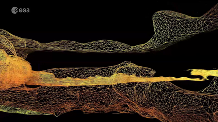
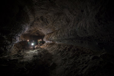
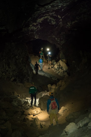
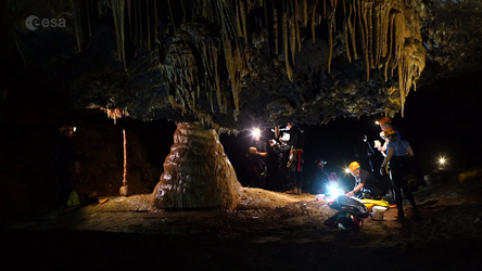
Volcanic wormhole
The organic and intricate features of a volcanic cave come alive in great detail in this three-dimensional image of La Cueva de Los Verdes in Lanzarote, Spain. Some of the most innovative scanning technologies have produced the largest 3D scan of a lava tube on Earth.
Lava tubes are planetary caves. Similar cave systems have been found from orbit on the Moon and Mars. These underground formations could one day provide safe habitats for humans on other celestial bodies – they provide constant temperature and a good shelter against cosmic radiation and micrometeorites.
Understanding the origins and formation of these caves on Earth is a passage for simulating the future of planetary explorers across the Solar System.
A team of speleologists from the University of Padova, Italy mapped the main path of the cave system aided by ESA astronaut Matthias Mauer. The image covers a 1.3 km section of the lava tube with an unprecedented resolution of few centimetres.
The expedition ventured last year into La Cueva de Los Verdes as part of ESA’s Pangaea-X campaign. Testing technologies and a full set of analysis tools was at the core of this course. The equipment could one day help to scout other planets.
Cut off from any satellite signal, in the dark and in rough terrain, two state-of-the-art instruments equipped with lasers and cameras mapped the cave. Using the point cloud technique, millions of measurements were merged in less than three hours to obtain a complete 3D model of the contours of the lava tube.
Although the lava tubes began to be mapped in the 1970s, a clear view of this subterranean passage was elusive until now.
The images are helping local institutions to protect this particular cave. Scientific data are shedding light on its origins and peculiar formations.
Learn more about the science and technology behind this campaign visiting www.blogs.esa.int/caves