About ESA
The European Space Agency (ESA) is Europe’s gateway to space. Its mission is to shape the development of Europe’s space capability and ensure that investment in space continues to deliver benefits to the citizens of Europe and the world.
Highlights


Latest


Space in Member States
Find out more about space activities in our 23 Member States, and understand how ESA works together with their national agencies, institutions and organisations.
 Germany
 Austria
 Belgium
 Denmark
 Spain
Spain
 Estonia
 Finland
 France
 Greece
 Hungary
 Ireland
 Italy
Italy
 Luxembourg
 Norway
 The Netherlands
 Poland
 Portugal
 Czechia
 Romania
 United Kingdom
 Slovenia
 Sweden
 Switzerland
Science & Exploration
Exploring our Solar System and unlocking the secrets of the Universe
Go to topicAstronauts


Latest


Enabling & Support
Making space accessible and developing the technologies for the future
Go to topicLatest


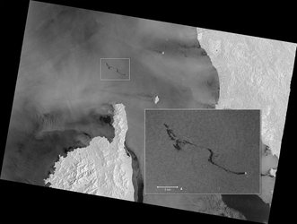
Oil spill spread
On 8 October 2018 at 05:28 GMT (07:28 CEST), the Copernicus Sentinel-1 mission captured its first images of the oil spill from a collision between two ships that had occurred the day before in the Mediterranean Sea, north of the French island of Corsica. This first image shows that the oil slick was about 20 km long. By the evening at 19:21 CEST, however, imagery shows that the slick had lengthened to about 35 km. And 24 hours later, on 9 October at 19:14 CEST, the slick had grown to about 60 km long.
Sentinel-1 is a two-satellite constellation built for the European Commission’s Copernicus environmental monitoring programme. The identical satellites each carry an advanced radar instrument that can ‘see’ through the dark and through clouds. Its wide swath allows large areas of Earth’s surface to be imaged so that events such as this can be detected and monitored easily. Satellite radar is particularly useful for monitoring the progression of oil spills because the presence of oil on the sea surface dampens down wave motion. Since radar basically measures surface texture, oil slicks show up well – as black smears on a grey background.
Note: the image from 9 October also shows a large black patch southeast of the oil slick – this is a result of low reflectivity of the radar signal and therefore depicts calm waters.