About ESA
The European Space Agency (ESA) is Europe’s gateway to space. Its mission is to shape the development of Europe’s space capability and ensure that investment in space continues to deliver benefits to the citizens of Europe and the world.
Highlights


Latest


Space in Member States
Find out more about space activities in our 23 Member States, and understand how ESA works together with their national agencies, institutions and organisations.
 Germany
 Austria
 Belgium
 Denmark
 Spain
Spain
 Estonia
 Finland
 France
 Greece
 Hungary
 Ireland
 Italy
Italy
 Luxembourg
 Norway
 The Netherlands
 Poland
 Portugal
 Czechia
 Romania
 United Kingdom
 Slovenia
 Sweden
 Switzerland
Science & Exploration
Exploring our Solar System and unlocking the secrets of the Universe
Go to topicAstronauts


Latest


Enabling & Support
Making space accessible and developing the technologies for the future
Go to topicLatest


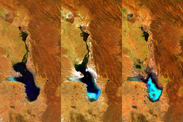
Proba-V view of Aral Sea
This Proba-V view shows all that is left of the Aral Sea, once one of the four largest lakes in the world and now one of the world’s major ecological disaster areas. It has shrunk into separate lakes, surrounded by Earth’s youngest desert.
The Aral Sea was once a large land-locked lake between Kazakhstan in the North and Uzbekistan in the South, possessing an area of 68 000 sq. km – twice that of Belgium.
However, the Aral Sea has dramatically shrunk since the 1960s when Soviet irrigation projects diverted water from the rivers supplying it. By the 2000s, the lake had shrunk to about 10% of its original size and by 2014 the horseshoe-shaped Southern Lake had virtually dried up.
Groundwater levels also fell, vegetation was laid waste and a once-thriving fishing industry collapsed. The exposed lakebed formed the newly-christened Aralkum Desert, spawning pesticide-laced sandstorms that can reach as far as the Himalayas.
Efforts to stabilise the situation are ongoing, including the replanting of hardy vegetation to reduce sandstorms. In 2005, the Kok-Aral Dam was completed to restore water levels in the Northern Lake – located at its bottom-east side. In addition, a sluice is periodically opened to replenish the Southern Lake.
Launched on 7 May 2013, Proba-V is a miniaturised ESA satellite tasked with a full-scale mission: to map land cover and vegetation growth across the entire planet every two days.
Its main camera’s continent-spanning 2250 km swath width collects light in the blue, red, near-infrared and mid-infrared wavebands at 300 m resolution and down to 100 m resolution in its central field of view.
VITO Remote Sensing in Belgium processes and then distributes Proba-V data to users worldwide. An online image gallery highlights some of the mission’s most striking images so far, including views of storms, fires and deforestation.
This 100 m-resolution image was acquired on 15 June 2018.
Proba-V is currently the subject of ESA’s latest ‘citizen science’ competition, requesting teams to produce ‘super-resolution’ images equivalent to its 100 m mode from sets of 300 m imagery.