About ESA
The European Space Agency (ESA) is Europe’s gateway to space. Its mission is to shape the development of Europe’s space capability and ensure that investment in space continues to deliver benefits to the citizens of Europe and the world.
Highlights


Latest


Space in Member States
Find out more about space activities in our 23 Member States, and understand how ESA works together with their national agencies, institutions and organisations.
 Germany
 Austria
 Belgium
 Denmark
 Spain
Spain
 Estonia
 Finland
 France
 Greece
 Hungary
 Ireland
 Italy
Italy
 Luxembourg
 Norway
 The Netherlands
 Poland
 Portugal
 Czechia
 Romania
 United Kingdom
 Slovenia
 Sweden
 Switzerland
Science & Exploration
Exploring our Solar System and unlocking the secrets of the Universe
Go to topicAstronauts


Latest


Enabling & Support
Making space accessible and developing the technologies for the future
Go to topicLatest


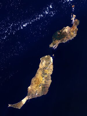
Easter Island
The Copernicus Sentinel-2 mission takes us over one of the most remote islands in the world: Easter Island. Located in the Pacific Ocean, over 3500 km off the west coast of South America, this Chilean island is also known as Rapa Nui by its original inhabitants. The island was given its current name the day Europeans arrived in the 1700s – on Easter Sunday.
The island is famous for its monolithic stone statues, called Moai, said to honour the memory of the inhabitants’ ancestors. There are nearly 1000 scattered around the island, usually positioned near freshwater. Many are located near the Rano Raraku volcano, on the southeast coast. The white edges along the southern coast show the harsh waves colliding with the shore.
An interesting feature of the image is the ochre-orange colour of the Poike – the peninsula on the eastern end of the island. In ancient times, it is said that there was a lot of vegetation on the island. However, land clearing for cultivation and the Polynesian rat played a role in deforestation, leading to the erosion of the soil, particularly in the east.
Several reforestation projects have been attempted, including a eucalyptus plantation in the middle of the island, visible in dark green. The brown patch to the right of the plantation is likely to be a burn scar from a wildfire.
The majority of the island’s inhabitants live in Hanga Roa, the main town and harbour on the west coast, clearly visible in the image. Interestingly, the long runway of the island’s only airport was once designated as an emergency landing site for the US space shuttle.
At the very edge of the southwest tip of the island lies Ranu Kao, the largest volcano on the island. Its shape is distinctive owing to its crater lake, one of the island’s only three natural bodies of water.
Many tourists are drawn to the island for its mysterious history and isolated position. What is relatively unknown is the existence of two small beaches on the northeast coast. Anakena beach has white, coral sand, while the smaller Ovahe beach, surrounded by cliffs, has pink sand.
Copernicus Sentinel-2 is a two-satellite mission. Each satellite carries a high-resolution camera that images Earth’s surface in 13 spectral bands. Data from Copernicus Sentinel-2 can help monitor changes in land cover.
This image, which was captured on 7 April 2019, is also featured on the Earth from Space video programme.