Introducing Biomass
ESA’s Biomass forest mission uses novel space technology to deliver new information about the state of our forests and how they are changing. Importantly, the Biomass mission will further our knowledge of the role forests play in the carbon cycle, and hence in the climate system.
Forests are a crucial part of Earth’s carbon cycle since they absorb and store large amounts of carbon from the atmosphere – thereby helping to keep our planet cool.
In fact, forests, often called ‘Earth’s green lungs’, absorb around 8 billion tonnes (net) of carbon dioxide from the atmosphere each year. However, deforestation and forest degradation, particularly in tropical regions, are causing stored carbon to be released back into the atmosphere, exacerbating climate change.
The challenge for scientific and climate policy communities is that they still do not know, with sufficient confidence, how much carbon is stored in the world’s forests, and how these stocks are changing over time in response to factors such as increasing temperatures, increasing concentrations of atmospheric carbon dioxide, and how they are changing because of the increasing needs of humans with respect to forests being cleared for agriculture and for urban growth, for example.
Quantifying the global cycle is essential to understanding the rapid changes that forests are undergoing and the subsequent implications for our climate.


Access the video
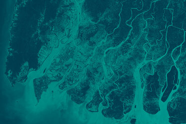
Forest type and forest cover worldwide can be detected by other satellites. However, Biomass is the first satellite to carry a P-band synthetic aperture radar – an instrument that can penetrate through the forest canopy to measure the ‘biomass’, meaning the woody trunks, branches and stems, which is where trees store most of their carbon.
This measurement of forest biomass can be used as a proxy for stored carbon, the quantification of which is the main objective of the Biomass mission.
Data from the Biomass mission will reduce the major uncertainties in calculations of carbon stocks and fluxes on land, including carbon fluxes associated with land-use change, forest degradation and forest regrowth.
Mapping forest biomass from space is a huge technical challenge. Forests are complex structures and different tree species and dense canopies make them difficult to measure from space.

Optical sensors offer a picture of forest extent, but only from the top of the canopy, not the structure beneath. Furthermore, tropical regions are typically covered by cloud, which further limits the use of optical sensors.
The Biomass satellite’s P-band synthetic aperture not only ‘sees’ through cloud cover, but slices through the whole forest layer. This results in the signal being scattered back to the satellite according to individual elements of the forest. The scattered back signal, therefore, carries information about the forest structure that can be used to infer parameters such as forest biomass and forest height.
Information from Biomass will also lead to better insight into rates of habitat loss and, hence, the impact this may be having on biodiversity in the forest environment.
In addition, the Biomass mission offers the opportunity to map subsurface geology in deserts, map the ice structure of ice sheets and map the topography of forest floors.
The Biomass satellite is designed and built by a consortium of more than 50 companies under Airbus UK as the prime contractor, many of these companies have subcontractors and suppliers.

Access the video
Back to Biomass homepage |