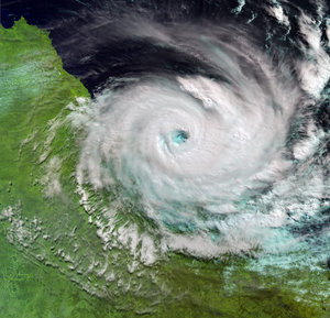

Typhoon Maemi - MERIS, 13 September 2003
The Medium Resolution Imaging Spectrometer (MERIS) instrument onboard Envisat satellite acquired this image of Typhoon Maemi over the Sea of Japan when it weakened into a tropical storm some hours later of tearing into South Korea (seen in the centre of the image). The typhoon hit the southern coast of the peninsula with gale winds blowing at a record 216 kilometres an hour. Media reported of at least 72 people were killed and 24 missing by the time the storm subsided. Maemi is the Korean name for a cicada that legend says chirps madly to warn of a coming typhoon. The mouth of the Yangtze River can also be seen in the bottom left part of the image spilling out sediments into the East China Sea about 23 kilometres north of Shanghai.
Technical Information:
Instrument: MEdium Resolution Imaging Spectrometer (MERIS)
Date of Acquisition: 13 September 2003
Orbit number: 08030
Orbit direction: Descending
Instrument features: Reduced Resolution image (1200 metre resolution)
Band combination: R = 753.75 nm, G = 560 nm, B = 442.5 nm
Coordinates:
NE Lat/Long: N 47.85/ E 139.79
NW Lat/Long: N 50.66/ E 124.35
SW Lat/Long: N 29.10/ E 119.42
SE Lat/Long: N 26.72/ E 130.95


