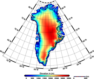
The European Space Agency (ESA) is Europe’s gateway to space. Its mission is to shape the development of Europe’s space capability and ensure that investment in space continues to deliver benefits to the citizens of Europe and the world.
Find out more about space activities in our 23 Member States, and understand how ESA works together with their national agencies, institutions and organisations.
Exploring our Solar System and unlocking the secrets of the Universe
Go to topicProtecting life and infrastructure on Earth and in orbit
Go to topicUsing space to benefit citizens and meet future challenges on Earth
Go to topicMaking space accessible and developing the technologies for the future
Go to topicThank you for liking
You have already liked this page, you can only like it once!
This animation of the Greenland results shows the boundaries (thick line) of the ice sheet and major ice divides (thin lines). The colours indicate ice sheet elevation change rate in centimetres per year (see colour scale). These values are derived from 11 years of ERS-1/ERS-2 satellite altimeter data, 1992–2003, excluding some ice-sheet marginal areas (white). The spatially averaged rate is +5.4 cm/year, or ~5 cm/year when corrected for bedrock uplift. The white areas between the colour-coded pixels and the thick line delimiting the ice sheet indicate no observations. Latitude in °N, longitude in °W.