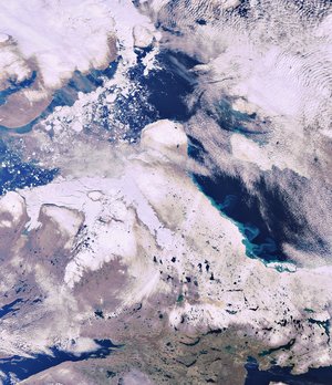

Envisat image of James Bay in Canada
Canada’s James Bay, featured in this Envisat's MERIS image acquired on 2 July 2007, is located between the provinces of Quebec (right) and Ontario (left). The bay, 443 km long and 217 km wide, contains numerous islands. The crescent-shaped Akimiski Island (visible) is the largest with an area of 3002 sq km. The two islands located 56 km northeast of Akimiski Island are the Twin Islands, while the large island visible at the very southern end of the bay is Charlton Island, 30 km long and 15 km wide in the centre. A collection of low-lying islands surrounds Charlton and the mouth of Rupert Bay (the muddy inlet visible in the lower right hand corner).
Polar Bear Provincial Park is located on the bay’s western shore in the far north of Ontario (visible in the upper left hand corner). Because the land in the park is flat, it tends to flood when the ice breaks up in late spring. Swirls of white winter sea ice breaking up are visible in the northern part of the bay across from the park. Sediments (visible along the shore in yellow, tan and brown) are carried to the bay from numerous local rivers.


