Applications
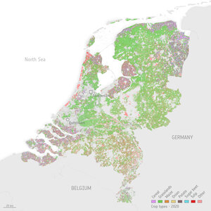
Crop type for all agricultural parcels Flevoland in the Netherlands
This figure zooms in on Flevoland in the Netherland to illustrate individual crop parcels. ESA worked with the Delft University of Technology in the Netherlands to develop Agricultural Sandbox NL, which makes use of radar data from Copernicus Sentinel-1 and optical, or camera-like, data from Copernicus Sentinel-2 and reduces terabytes of satellite data to just 10 gigabytes per year. Importantly, this dataset tool makes these data perfect for non-expert data users in the agriculture sector.
Read full story: Monitoring crop health across the Netherlands