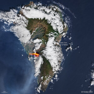

Rising heat below La Palma volcano
In September 2021 the Cumbre Vieja volcano on the Spanish island of La Palma started erupting – an eruption that continued for almost three months. The fact that this volcano erupted came as less of a surprise to geoscientists using satellite data to study changes in temperature deep below Earth’s surface. As part of the effort to understand the complexities of Earth’s interior, scientists working within ESA’s Science for Society 3D Earth project, developed a state-of-the art models of the lithosphere, which is a term to describe Earth’s brittle crust and the top part of the upper mantle, and the sub-lithospheric upper mantle down to 400 km depth. The model combines different satellite data, such as gravity data from ESA’s GOCE mission, with in-situ observations, primarily seismic tomography. The model shows differences in temperature, or thermal structures, indicated that the La Palma volcano was due to erupt at some point.
A branch of the Azores plume is visible from the surface down to a depth of 400 km, at the base of the upper mantle. The plume flows southeast towards Madeira and the Canary Islands surrounding the cold mantle beneath the north Atlantic’s African margin.
Read full story: Deep down temperature shifts give rise to eruptions


