Applications
Destruction in Turkish city of Antakya
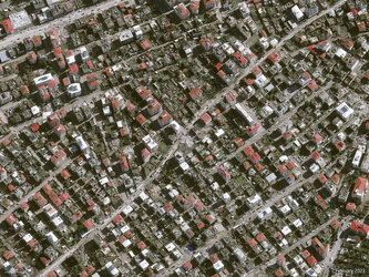
This animation shows the destruction of the Turkish city of Antakya after the devastating earthquake that struck Türkiye and Syria on 6 February. The first image, captured by Copernicus Sentinel-2, show the city of Antakya before the earthquake on 25 January 2023, while the second image shows the city on 14 February 2023.
In response to the earthquake, the International Charter ‘Space and Major Disasters’ was activated. By combining Earth observation assets from different space agencies, the Charter provides satellite images of the affected areas to define the extent of the disaster and support local teams with their rescue efforts.
Read the full article: Satellites support impact assessment after Türkiye–Syria earthquakes