Autonomous surface feature tracking
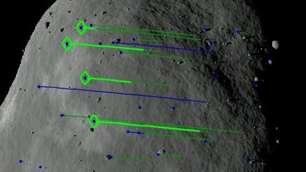
Once we come closer than 2 km then Dimorphos will fill Hera’s field of view. Then comes the most ambitious navigation mode of all, based on autonomous surface feature tracking with no absolute reference. This will be a matter of imaging the same features – such as boulders and craters – in successive pictures to gain a sense of Hera’s altitude and trajectory with respect to the surface.
Feature identification and mapping will also be used to derive the mass of Dimorphos, although this technique will be performed from the ground rather than aboard the spacecraft.
Mission controllers will measure the ‘wobble’ the moonlet causes to its parent, relative to the common centre of gravity of the overall Didymos system. This will be achieved by identifying small metre-scale variations in the rotation of fixed landmarks around this centre of gravity over time.


