Webinar recap: Space solutions to ocean problems
From absorbing heat to producing oxygen, Earth's oceans are vital to the survival of humans and many other species. However, acidification, plastics and global warming endanger this vital resource and its biodiversity. ESA and its partners are committed to exploring solutions that safeguard the deep blue worlds.
In a move to put into action our responsibility to protect the oceans, ESA's Blue World Task Force organised two webinars in June to explore ground-breaking space solutions to ocean problems. In the first webinar, speakers talked about how space can improve and innovate safety and security in the oceans, while the second webinar explored space solutions for a greener maritime future.
Safety and security in the oceans
Humans do a lot with the oceans. We travel for leisure, fish, and produce energy on offshore platforms – the list goes on. To do all this, navigating the ocean is crucial, and maritime safety is increasingly relevant. After all, once at sea, knowing weather forecasts or what navigational hazards are out there is key to ensuring safety on board.

The first webinar speaker, Lars Løge, VDES Programme Manager for Space Norway AS, talked about the status of projects in the works that will pave the way for faster communications between ships and maritime authorities. Communications will improve even in remote areas like the Arctic, where infrastructure is less available.

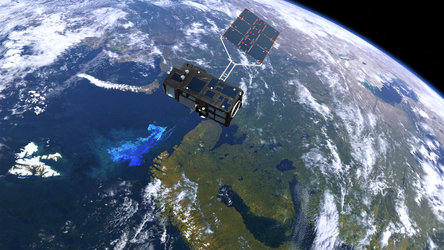
Afterwards, Pierre Potin, Copernicus Sentinel-1 mission manager at ESA, showcased the mission's ability to precisely cue and locate ships' activities at sea. Sentinel-1 can collect such information under all weather conditions and during day or night thanks to its radar instruments. In 2021, for example, during the infamous Suez Canal traffic jam, it collected images from space that clearly depicted where each ship was. The sea surface reflected the radar signal away from the satellite, making water appear dark in the picture. On the other hand, the ships appear as bright dots, contrasting with the dark waters.
Next, Stelios Bollanos, Director of Planetek Hellas, gave an overview of the company. Planetek Hellas uses systems that monitor the environment and critical infrastructure to help with urban planning, civil protection and security. Stelios Bollanos focused on the importance of satellite observations in border surveillance, namely on tracking illegal immigration along Greece and Turkey's maritime and terrestrial borders.
Space for a greener maritime future
This webinar focused on ESA's responsibility towards protecting the ocean under three main topics: port management, monitoring the Arctic and ocean litter.
The first presenter, Alan Wells, professor emeritus in space technologies at the University of Leicester, introduced Cache 22, a project linked to the ESA initiative 'Space for Ports of the Future'. Ports are critical to all nations, making worldwide trading and commercial exchanges possible. In fact, around 80 percent of international trade in goods is carried by sea. However, these crucial infrastructures are highly polluting and in need of innovation. 'Space for Ports of the Future' is modernising ports, making them greener, more automated and safer.

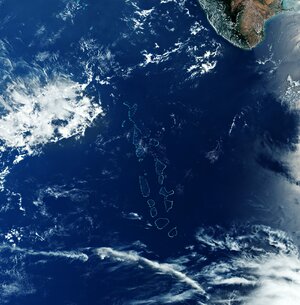
During the webinar, stakeholders showed projects already supporting Europe's ports. That's the case of Port XXI, a project introduced by José Moutinho, chief business and networking officer of the AIR Centre in Portugal. Researchers at Port XXI are working in the ports of the Azores islands, a Portuguese archipelago in the Atlantic Ocean. They have two main goals: improve the management of ports and achieve zero pollution in said ports. To do so, they're using Earth observation, meteorological, oceanographic and CCTV data to create real-time monitoring solutions and forecasting tools.

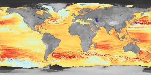
Moving onto the second webinar topic, Mal McMillan, from the UK Centre for Polar Observation and Modelling and Joakim Kugelberg, Arctic Weather Satellite project manager of OHB Sweden, talked about the Arctic. Climate change has a clear impact on ice melt and, consequently, on sea level rise worldwide. In a study from late 2021 based on measurements from ESA's CryoSat mission, scientists reported that extreme ice melting events in Greenland are now more frequent and intense. This raises sea levels and the risk of flooding worldwide. During the talk, both speakers gave an overview of how Earth observation satellites can help monitor the Arctic weather and the climate transformation our planet is facing.
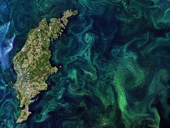
Lastly, Eva Haas, Head of Strategic Accounts Europe of EOMAP, and Amandine Declerck, an expert on Ocean Modelling and Forecasting for Suez-Rivages Pro Tech, talked about marine litter and how to track it from space using Earth observation data.

Since you started reading this article, one million plastic drinking bottles have been purchased all over the world. Some of them will end up in the oceans. There's an increasing demand for solutions that track ocean plastics efficiently to tackle this problem. During their presentations, Eva talked about how EOMAP uses data from the Copernicus Sentinel-2 mission to track water on and under the ocean surface, and Amandine talked about the PlastEcoTrack feasibility project. This, however, isn't the first time researchers have explored the abilities of the Copernicus Sentinel satellites to track litter from space. In 2017, the Motagua river in Guatemala flooded the Honduras bay with a tide of plastic litter. Moved by this unfortunate event, scientists from Greece created new marine litter monitoring solutions using multispectral data from Sentinel-2, and the results are publicly available.
ESA will host more open webinars in autumn to showcase other ground-breaking projects that protect Earth’s oceans. For these and other updates on the webinars, as well as other news about how advancements in space can improve life on Earth, follow us on Twitter.