ESA
Education
Hjem
Vejr og klima
Globale forandringer
Naturkatastrofer
02-Aug-2025
Jordskælv
Indledning
Izmit jordskælvet
Orkaner
Stormfloder
Orkanen Katrina
Oversvømmelser
Thessaloniki (Grækenland)
Vulkaner
Introduktion
Andesbjergenes vulkanske bælte
Etna
Nyiragongo og Nyamuragira
Søg
Article Images
Øvelse 1: Orkanen Katrinas spiral fra toppen af skyerne og til havets bølger - Fortsat
Tilbage til artiklen
Download:
HI-RES JPEG
(Size:
43 kb
)
Credits: ESA
Tilbage til artiklen
Download:
HI-RES JPEG
(Size:
40 kb
)
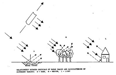
Relationship between greyscale of radar images and backscattering of different targets
Credits: ESA
Stormfloder
Indledning
Orkanen Katrina
Indledning
Øvelser
Øvelse 1: Orkanen Katrinas spiral fra toppen af skyerne og til havets bølger
Øvelse 2: Visualisering og undersøgelse af de oversvømmede områder i New Orleans forårsaget af orkanen Katrina
Eduspace - Software
LEOWorks 3
Eduspace - Download
Envisat and SPOT data (zip)
Related links
Hurricane Katrina - NOAA
Hurricane Katrina - Wikipedia
National Hurricane Center - NOAA
Storm surge overview - NOAA
Global Monitoring for Environment and Security - ESA
International Charter Space and Major Disasters
Tropical weather and hurricanes - Physicalgeography
Related news
Envisat sees whirling Hurricane Katrina from ocean waves to cloud tops
Related videos
Cyclone Floyd - 9 September 1999
(0.7 Mb)
Cyclone Floyd - 13 September 1999
(1.5 Mb)
Cyclone Floyd - 14 September 1999
(1.6 Mb)
Cyclone Floyd - 15-16 September 1999
(3.4 Mb)
Copyright 2000 - 2014 © European Space Agency. All rights reserved.