|
Earthquake damage assessment simulation
The exercise results will form the contents of a detailed report to be used by Civil Protection Authorities. The general methodology applied can be re-used in similar cases and with other similar, available data sets.
Find the area in your atlas before starting. Look for Turkey and for Istanbul, first. Then consult a detailed map to locate towns and other features. You also need a geologic and tectonic map to study the fault lines in the area. What is the fault direction? Discuss your findings. A risk (earthquake) map can be retrieved from this website. Find and consult it! Is this a 'high risk' area?
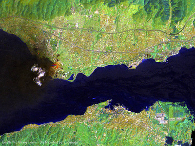
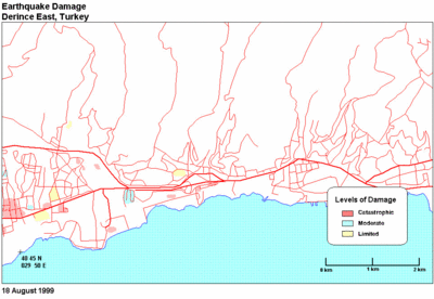
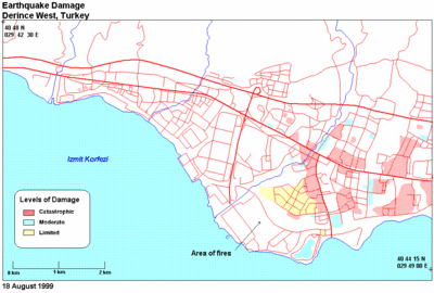
To start the exercise, compare the Landsat image with the east and west maps (below). Display the satellite image and the maps at a common scale (zoom in in order to obtain it).
Check the two information types carefully. The map mainly shows roads. Where the road network is dense, roads become streets, and built-up areas appear. Now you can learn how to distinguish urban from rural areas by means of a satellite image. Assess colour and texture of both land cover types! Identify 6 classes of built-up areas by their colour and texture: 2 for industrial areas and 4 for residential areas. You may have industries of intensive (large factory buildings) or extensive (buildings with deposits and some free ground) type. Residential areas are discriminated by different colour and, especially, texture (coarse or fine texture, rectangular buildings, well defined white blocks, and similar). Compile a legend.
Look at the maps for damaged areas and locate these in the corresponding satellite image. Mark the severely damaged areas on the satellite image. Annotate (with an alphabetical letter) every single street or block partially or completely damaged. How many damaged blocks did you find?
Analyse the result by counting the damaged industrial and residential areas compared to the original 6 class classification. Draw a small table with 4 columns and 7 rows. The 4 columns are: class (1 to 6), short description of class, number of damaged blocks and percentage of total number of blocks damaged in a given class. This number has to be worked out by counting the blocks affected by severe damage for each one of the 6 classes.
Conclusion: Did you find a class of residential area more damaged than others? If so, describe this class (or classes) in detail by marking it/them on the satellite image. Write a brief report, outlining the method you have followed and the results you have obtained. The next step is to inspect all quarters in that area/town and document them with pictures. Ideally this is a local person's task. However.... you have achieved the objective of your exercise and confirmed that satellite images can help with the assessment of typology and building strength for earthquakes, despite very poor ground information. It would now be up to local authorities to take appropriate action so that they are prepared for any forthcoming earthquake! Last update: 18 April 2013
| ||||||||||||||||||||||||||||||||||||||||