Observed objects


 |  |
Meteorological satellites
| |
Remote sensing techniques are implemented in function of what needs to be observed. For instance, orbit parameters
are related to monitoring requirements. The Earth can therefore be observed at different scales.
This could be compared to a photograph of a mountain. If you are too close to the mountain, you cannot see all of it in the camera's viewfinder and you can only take a picture of part of it, or move further away to take the picture until you can see it all at once.
To have a picture of the Earth as a whole disk, the satellite has to be further away from the planet. But a satellite on its orbit cannot change course. So when an image of the planet (as a whole disk) is required, a different satellite on an orbit
further away is used.
 |  | | |
Earth's surface
|
Note: As the Earth is spheroidal, it is impossible to see the whole planet at once - it is only possible to see one side at a time. This is why, in an image taken from a distance, the Earth looks like a disk.
Alternatively, if scientists want to have a picture of a larger part of the Earth’s surface, they program the sensor onboard
the satellite to take several images next to each other. By mosaicing the images, it is possible to obtain a view of a larger
area on the ground and even of the whole planet, although not at the same time.
On the image above, the satellite is placed on an orbit relatively far from the Earth (± 36,000 km). This is why it is
possible to see the 'whole' planet.
 |  |
Each square represents one image
| |
On the image on the left, the satellite orbit is much closer to the Earth (±800 km). Each square (black and red) represents one image. When
several images are joined together to form a bigger image, scientists refer to it as a 'mosaic'.
 |  | | |
West London TM image
|
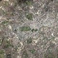
Sometimes scientists just want to observe a particular feature in more detail by 'zooming' into a small part of the Earth’s surface.
This could be compared with the photograph of a mountain: if the object that you are interested in is a house with a barn, you will
need to zoom into the mountain photograph to see it properly. If you take a picture of the whole of the mountain, the likelihood of
seeing the house and barn in any detail is very small. The image on the right is a satellite image of London.
 |  |
West London aerial map
| |
The image on the left is an aerial photograph of London. The choice about which
one is most appropriate to use will depend on the kind of task at hand. For example, to measure the growth of a town, the satellite image will be best, but to measure the traffic density on the Thames, the aerial photograph will be better.
Scientists may decide to pay attention to some phenomena on the Earth’s surface. In this case, they will want to 'zoom' in and track
a particular feature rather than a specific region. For example, they might decide to 'zoom' into a hurricane, a forest fire or a flood.
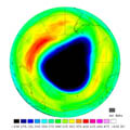
When satellite imagery is used to observe specific types of features or events, this is called 'satellite applications'. For example, one of the applications of the ERS satellite is to monitor the evolution of the ozone hole above Antarctica.
 |  |
Ozone hole over the South Pole, September 2001
| |
The image on the left shows the ozone hole above the South Pole. The ERS satellite has an instrument able to measure the
quantity of ozone found in the atmosphere.
The darker the image is, the less ozone is measured by the instrument. Scientists can therefore talk about a hole in the ozone layer above Antarctica, as that area on the image is extremely dark, meaning that the quantity of ozone is very low.
Can you think of other satellite applications?
* See answer at the bottom of the page
If you want to learn more about satellite applications, you can also visit the Eduspace website’s sections on Global Change
and Disaster Monitoring.
* Answer : monitoring of forest fires, tropical cyclones, floods, etc.
Last update: 7 December 2009

 |  | 
Elements of remote sensing

| | • | Platforms (http://www.esa.int/SPECIALS/Eduspace_EN/SEM2BR3Z2OF_0.html) |  | | • | Sensors (http://www.esa.int/SPECIALS/Eduspace_EN/SEM4GR3Z2OF_0.html) |  | | • | The information contained in an image (http://www.esa.int/SPECIALS/Eduspace_EN/SEM4HR3Z2OF_0.html) |  |

|

