
Envisat

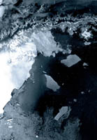 | |
ASAR looks at the Antarctic Peninsula
| |
Envisat was launched on 1 March 2002. An advanced polar-orbiting Earth Observation satellite, it provided measurements of the atmosphere, ocean, land, and ice.
Envisat data supported Earth science research and enabled the monitoring of environmental and climatic changes. Furthermore, its data facilitated the development of operational and commercial applications. The Envisat mission ended on 8 April 2012.
The Advanced Along Track Scanning Radiometer (AATSR) established continuity of the ATSR-1 and ATSR-2 datasets of the ERS series for precise sea surface temperature (0.3 K or better) measurements to assist climate research and for operational and scientific users.
An Advanced Synthetic Aperture Radar (ASAR), operating at C-band, ensured continuity of data after ERS-2. It featured enhanced capability in terms of coverage, range of incidence angles, polarisation, and modes of operation. The improvements allowed radar beam elevation steerage and the selection of different swaths, 100 or 400 km wide.
MERIS is an imaging spectrometer that measured the solar radiation reflected by the Earth at a ground spatial resolution of 300 m, with 15 spectral bands in visible and near infra-red, and programmable in width and position.
| 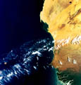 | | |
West Coast of Africa - First MERIS image
|
MERIS allowed global coverage of the Earth every 3 days. The primary mission of MERIS was the measurement of sea colour in oceans and coastal areas. Knowledge of sea colour can be converted into a measurement of chlorophyll pigment concentration, suspended sediment concentration, and aerosol loads over marine areas, all of which are important for the study of ocean carbon cycle and upper ocean thermal regime. The data could be used for management of fisheries and coastal zones.
In order to understand the processes which determine the physical and the photochemical behaviour of the atmosphere, detailed global measurements of the amount of horizontal and vertical distribution of ozone, in addition to many other atmospheric trace-gases, are necessary. Onboard Envisat the following sensors provided relevant data:
- The Global Ozone Monitoring by Occultation of Stars (GOMOS)
- The Michelson Interferometer for Passive Atmospheric Sounding (MIPAS)
- The SCanning Imaging Absorption SpectroMeter for Atmospheric ChartographY (SCIAMACHY)
Last update: 19 February 2014
| |
Earth observation satellites
| | • | Introduction (http://www.esa.int/SPECIALS/Eduspace_EN/SEM7YN6SXIG_0.html) | | | • | Landsat (http://www.esa.int/SPECIALS/Eduspace_EN/SEMHB04Z2OF_0.html) | | | • | ERS (http://www.esa.int/SPECIALS/Eduspace_EN/SEMFZ04Z2OF_0.html) | | | • | RESURS (http://www.esa.int/SPECIALS/Eduspace_EN/SEMQ614Z2OF_0.html) | | | • | SPOT (http://www.esa.int/SPECIALS/Eduspace_EN/SEMIW04Z2OF_0.html) | |
Meteorological satellites
| | • | Meteosat (http://www.esa.int/SPECIALS/Eduspace_EN/SEM6BY3Z2OF_0.html) | | | • | Meteosat Second Generation (http://www.esa.int/SPECIALS/Eduspace_EN/SEMTNY3Z2OF_0.html) | | | • | MetOp (http://www.esa.int/SPECIALS/Eduspace_EN/SEMS1O6SXIG_0.html) | | | • | NOAA (http://www.esa.int/SPECIALS/Eduspace_EN/SEMDQY3Z2OF_0.html) | |
Earth Explorer satellites
| | • | Introduction (http://www.esa.int/SPECIALS/Eduspace_EN/SEMUYN6SXIG_0.html) | | | • | GOCE (http://www.esa.int/esaLP/LPgoce.html) | | | • | SMOS (http://www.esa.int/esaLP/LPsmos.html) | | | • | CryoSat-2 (http://www.esa.int/esaLP/LPcryosat.html) | |
Commercial high resolution optical satellites
| | • | IKONOS (http://www.esa.int/SPECIALS/Eduspace_EN/SEMI714Z2OF_0.html) | | | • | QuickBird (http://www.esa.int/SPECIALS/Eduspace_EN/SEMZ814Z2OF_0.html) | | | • | WorldView (http://www.esa.int/SPECIALS/Eduspace_EN/SEM43O6SXIG_0.html) | |
More information
| | • | Envisat overview (https://earth.esa.int/web/guest/missions/esa-operational-eo-missions/envisat) | | | • | Technical specifications - Envisat (http://esamultimedia.esa.int/img/2014/02/ENVISAT.pdf) | |
|
