Background


 |
Ocean Continent Convergence
|
Central Andes is defined as the area between 27º South, at the southern edge of the Puna (the high Andean plateau ), and 39º South at Lake Aluminé, between longitudes 69º and 71º West. It forms an elongated strip of high mountainous relief. The region contains the highest point of the Americas, Aconcagua, which rises 6,959 m above sea level.
The origin of these mountains can be explained using the tectonic plates theory. The Oceanic Crust submerges and causes movement (folding, volcanoes, earthquakes) on the Continental Crust. In this region earthquakes are frequent. On 27 February 2010 an earthquake of a magnitude of 8.8 on the Richter Scale took place off the coast of Central Chile.
The movement of the Continental Crust creates an asymmetrical profile which in turn causes an abrupt western slope and a slight east-lying slope, forming a continuous mountain chain. It acts as a drainage divide, and defines the boundary between Argentina and Chile.
 |
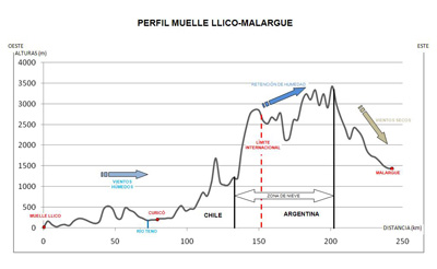
Profile between Muelle Llico (Chile), 34°45’16”S 72°05’03”W and Malargue (Argentina), 35°30’S 69°35’W
|
This mountain range represents a barrier that forces the westerly winds to rise. On the western side of the range (Chile) there is copious orographic precipitation feeding rivers, ice fields, and glaciers. On the Argentinean side of the Andes - east of the mountain range - the winds are dry, a consequence of the rainfall occurring on the opposite side. As these winds move down the mountain, they create low humidity, which results in desert-like areas.
Last update: 16 April 2013

 |  | 
Lost in the Andes!

| | • | Lost in the Andes (http://www.esa.int/SPECIALS/Eduspace_Global_EN/SEMPSH52Q8H_0.html) |  | | • | Introduction (http://www.esa.int/SPECIALS/Eduspace_Global_EN/SEMFUH52Q8H_0.html) |  | 
Exercises

| | • | Exercise 1: The Andean region (http://www.esa.int/SPECIALS/Eduspace_Global_EN/SEMA8I52Q8H_0.html) |  | | • | Exercise 2: Vegetation cover (NDVI) (for university students) (http://www.esa.int/SPECIALS/Eduspace_Global_EN/SEMJSX52Q8H_0.html) |  | | • | Exercise 3: The geographical setting of the accident (http://www.esa.int/SPECIALS/Eduspace_Global_EN/SEM2O962Q8H_0.html) |  | | • | Exercise 4: The route back to civilisation (http://www.esa.int/SPECIALS/Eduspace_Global_EN/SEM3RB62Q8H_0.html) |  | | • | Exercise 5: Expedition “Alive!” (http://www.esa.int/SPECIALS/Eduspace_Global_EN/SEMFIC62Q8H_0.html) |  | | • | Exercise 6: A multidisciplinary workshop (http://www.esa.int/SPECIALS/Eduspace_Global_EN/SEMABF62Q8H_0.html) |  | 
Eduspace - Software

| | • | LEOWorks 3 (http://esamultimedia.esa.int/multimedia/LEOWorks3.exe) |  | | • | LEOWorks 4 (MacOS) (http://leoworks.asrc.ro/download/leoworks.app.zip) |  | | • | LEOWorks 4 (Windows) (http://leoworks.asrc.ro/download/leoworks.exe) |  | | • | LEOWorks 4 (Linux) (http://leoworks.asrc.ro/download/leoworks.jar) |  | 
Eduspace - Download

| | • | Lost_in_the_Andes.zip (http://esamultimedia.esa.int/eduspace/Lost_in_the_Andes.zip) |  | 
More on the Andes tragedy

| | • | Wikipedia summary (http://en.wikipedia.org/wiki/1972_Andes_flight_disaster) |  |

|

