|
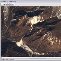
Landslide detection in Langtang Himal - Part 2 This exercise is divided into two parts and requires the use of LEOWorks. At the centre of the images you should be able to identify a landslide. If you have difficulty finding it, look at the figure for identification help.
1. Guess what area this landslide covers.
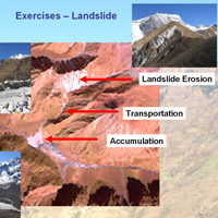
A landslide can usually be divided into 3 parts:
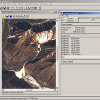
Go to Image>Measure tool and a new window will open. Click Units>Meters. Carefully digitise, with the crosshair, the boundary of the landslide erosion zone. Click on your right mouse button once you are finished.
It is the area of the landslide in square metres. Do the same for the transportation zone, and measure the distance between the erosion and accumulation zone. As a last step, measure the area of the accumulation zone.
1. Compare the measured area with your guesses.
2. Can you imagine an area of that size? 3. How many football fields would fit into an area of that size? The international standard for a football field is 68 x 105 m. Last update: 18 April 2013
| ||||||||||||||||||||||||||||||||||||||||||||||||||||||||||||||||||||||||||||||||||||||||||||||||||||||||