|
Exercise 2 - Annapurna Circuit - Continued
ArcExplorer provides some useful Classification Options. The objects in a shape file or a layer have internal properties saved in the database as attributes. These attributes can be used to enhance the GIS files by classifying the features.
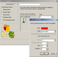
The City Lodge layer, for example, has the attribute ID, which can have the values 0 for the lodges, 1 for the cities and 2 for the base camp(s). Open the Theme Properties for the City Lodge layer and choose Unique Values. Select the field 'ID' and click on the symbol for ID 0. The Symbol properties menu opens. ID 0 means lodges. Choose an orange Circle marker Size 10 and click OK. ID 1 means cities. Choose a red Circle marker Size 15 for the cities. The last ID 2 stands for the base camp(s). Choose a green Triangle marker Size 10 for this class. The City Lodgelayer is now grouped and uses the selected properties for the different groups of ID's.
Count the number of lodges, cities and base camps and review the results using the ID's in the Query Builder.
A different method of classification is called 'statistical grouping'. Here the values are subdivided into different classes, for instance the height of the mountains. Open the menu Theme Properties in the Peak layer and choose Class Breaks. Select Height for Numeric field and 3 for Number of classes. Choose a grey to brown Color ramp and a Symbol size 10 to 25.
Count the number of mountains for each class and review the results using the Heights in the Query Builder.
Geographic information systems, GIS, also offer the option of creating simple maps using the information saved in the database. Create a map of the Annapurna Circuit following the steps given below. First, change the City Lodge layer and the Peak layer to the original properties. Then open the Theme Properites in the City Lodge layer and choose No Overlapping Labels in Classification Options. Select Name in the Text field and choose a bold, red font Placed on with a Label size of 60 and a Distance from feature of 10. Follow the steps for the Peak layer and choose useful options. For example, place the name of the mountain below the symbol. Add the Peak layer a second time, choose Height instead of the name, and place it above the symbol. Now you should have a simple map of the Annapurna Circuit.
Name the advantages and disadvantages of a map produced using GIS as opposed to a 'normal' topographic map, and explain the reasons. What kind of difficulties do you expect to encounter with the Annapurna Circuit? What do you think of altitude sickness? Is there enough time to acclimatise on the trek before entering the high altitude zone? What is the highest altitude you have been to? Would you be prepared for a 21-day trip? That includes outdoor equipment and clothes. What equipment and clothes would you pack into your backpack? Do you know about the risk of serious diseases within the Annapurna Conservation Area? How would you protect yourself against such dangers? By the way, this is a good chance to check your vaccination certificate. Are you still vaccinated against polio, tetanus, diphtheria and hepatitis A and B? Discuss the pros and cons of tourism for the Annapurna region and the country as a whole with your classmates. What do you understand about so-called eco-tourism? Discuss the possibility of eco-tourism in the Himalayas. Which large-scale changes have to be made to combine environmental protection and tourism? What action has been taken by the KMTNC since the Annapurna Conservation Area Project started in 1986? Do you know of any regions where this type of project has succeeded? Could the action taken there be transferred to the ACA? Last update: 16 April 2013
| ||||||||||||||||||||||||||||||||||||||||||||||||||||||||||||||||||