
Exercise 1: Contributing to a cleaner ocean

 | |
Braer oilspill, Shetland Islands, Scotland
| |
Only a few countries in the world have pollution control along their coasts, and patrol regularly using ships or aircraft. A new way of monitoring our seas is from space, using orbiting satellites such as the ERS satellites built and launched by ESA.
The ERS satellites have a radar onboard that is able to watch the Earth's surface at all times, even through clouds and during the night. Radar images look similar to photographs, but their interpretation is different (for more information, see the article on radar technology).
| 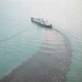 | | |
Ship dumping sewage in the North Sea
|
Marine oil pollution is not only caused by accidents. The biggest contributor to oil pollution in the world's oceans comes from operational discharges from tankers (i.e. oil dumped during cleaning operations). The amount of oil introduced in the sea by such operations is equivalent to one full tanker disaster every week!
 | |
Oil dumped during cleaning operations
| |
In a radar image, the ocean is not blue but black and white, and may also appear to have a lot of strange features. As a general rule, the brighter the sea surface, the rougher the sea (because wind speed is higher). But oil on water dampens the rough surface and it becomes smooth again (and dark, as is shown in the image).
|  | | |
In a radar image the ocean is black and white
|
Ships appear as bright points. Why is this? What produces a very long black trail behind a ship? It is not merely a wake, but proof that the ship is washing out its oil tanks. An operation that pollutes our seas and is illegal, at least in the Mediterranean Sea.
And this is an image of the Mediterranean Sea, off the coast of France.
The story began early last spring, on a calm but misty day. Patrolling aircraft of the French Coast Guard observed a ship spilling oil. At 09:50 GMT they reported: Spilling ship in position 7°12'E 42°14'N , spill is about 4000 m long and 100 m large, and is of light oil of a silver colour.
 | |
ERS-2 satellite
| |
At 10.17 GMT of the same day, the ERS satellite passed over this area. We want you to take on the role of the Alert Operator who analyses the satellite image and will eventually give the French Coast Guard more evidence to confirm their observation, whilst also putting it in context of the much larger area (as space imagery allows you to do).
From the image it seems that the spill is much longer than what the aircraft could see. The spill has been interrupted, for whatever reason.
Here is the image (or download from Eduspace-Download in the right navigation column).
Open the image. Once the image is open, the cursor position is indicated in the left lower corner as Latitude and Longitude. Find out the position of the ship.
By clicking and holding the left mouse key and then moving the mouse, you can measure the distance from one point to another point on the image.
You can also do this exercise using LEOWorks. You can download the file from the download link 'Contributing to a cleaner ocean (LEOWorks)' on the right of this page.
What is the length of the oil spill behind the ship? Was the spill interrupted? Look at the questions in the form below and fill it in by carefully making your measurements on the screen!
Complete the exercise. Download the printable version of the exercise here.
Thanks for your contribution! I think the Coast Guard now has enough evidence to prosecute the ship's captain. Next time that captain will think twice before illegally discharging oil in the sea!
Last update: 15 October 2013
| |
Oil spills
| | • | Introduction (http://www.esa.int/SPECIALS/Eduspace_Global_EN/SEMVJGBNJTF_0.html) | |
Exercises
| | • | Help! A huge oil slick is approaching the coast! (http://www.esa.int/SPECIALS/Eduspace_Global_EN/SEM93IBNJTF_0.html) | | | • | Exercise 3: Oil rig environmental disaster (http://www.esa.int/SPECIALS/Eduspace_Global_EN/SEMTKGBNJTF_0.html) | |
Links
| | • | Norwegian Pollution Control Authority (SFT) (http://www.sft.no/english/) | |
Eduspace - Software
| | • | LEOWorks 3 (http://esamultimedia.esa.int/multimedia/LEOWorks3.exe) | |
Eduspace - Download
| | • | Oil rig environmental disaster (PDF) (http://esamultimedia.esa.int/docs/eduspace/oilrigb.pdf) | | | • | Help! A huge oil slick is approaching the coast! (http://esamultimedia.esa.int/EDU/seaandspace/oilspill.html) | | | • | Help! A huge oil slick is approaching the coast! (using LEOWorks) (http://esamultimedia.esa.int/images/910913_910919_910925_rgb_geo.tif) | | | • | Help! A huge oil slick is approaching the coast! (report form) (http://esamultimedia.esa.int/docs/eduspace/report-oil.pdf) | | | • | Contributing to a cleaner ocean (http://esamultimedia.esa.int/EDU/seaandspace/contrib.html) | | | • | Contributing to a cleaner ocean (report form) (http://esamultimedia.esa.int/docs/eduspace/report-spill.pdf) | | | • | Contribution to a cleaner ocean (LEOWorks) (http://esamultimedia.esa.int/eduspace/2013/11/contribution_to_a_cleaner_ocean.tif) | |
|
