|
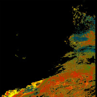
The coast of Africa
The pseudo-coloured image shows the relative chlorophyll content of the sea from green (low) to red and yellow (high). Land and clouds are detected after complex processing and are excluded (black).
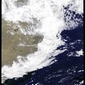
Compare these locations with the 'normal' colour image.
Does this maximum concentration have to do with the vicinity of the coast, or with the warm sea current? What is the name of this current? Look this up in your atlas.
In order to read the other files in the zipped directory, see the instructions in the 'chlorophyll concentration exercise' by clicking on the link on the right of this page. Mind you, it is scientific stuff!
Click to download data, 1.0Mb.
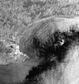
Like all radar images, clouds are not visible because radar, contrary to optical imaging instruments that use sunlight, use microwave for imaging. Microwaves penetrate clouds and mist, and always provide a clear picture.
Cities are marked with many bright points. Look at the detailed radar image of Port Elizabeth, where the Antarctica adventure began.
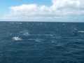
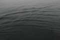
Can you recognise the harbour? Observe the beach resorts east of the town with the many houses lined up. Study how differently the sea surface is imaged depending on the local wind condition - the brighter the image, the rougher the surface, and hence the higher the wind speed (see photos illustrating this). The bright points near Port Elizabeth are anchored ships.
See high going sea image.
And see calm sea surface. Last update: 18 April 2013
| ||||||||||||||||||||||||||||||||||||||||||||||||||||||||||||||||||||||||||||||||||||||||||||||||||||||||||||||||||||||||||||||||||||||||||||||||||